Search the entire catalogue by entering a key search term in the ‘search’ box or browse our stock by selecting from the list of categories below.
MAPS ASIA
![]()
JAPAN
![]()
|
|||||||||||||
|
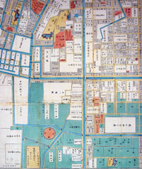
Cartographer : | Tomatsu Masakuni | |||||||||||
| Title : | Honjo Fukagawa Ezu (Map of Honjo Fukagawa) | ||||||||||||
| Date : | 1858 | ||||||||||||
| Size : | 29in x 21in (740mm x 535mm) | ||||||||||||
| Description : |
This is a wonderful
and unique opportunity to acquire a rare piece of
antique Japanese cartography. This large beautiful
wood-block hand coloured & original map of the old
Fukagawa district of the Koto-Ku Ward of Tokyo Bay was
published in the Ansei 5th Year (1858) by Owariya
Seihichi and illustrated by Tomatsu Masakuni. Fukagawa is located 2km east of
Nihombashi, on the Eastern side of the Sumida river,
across Eitai bridge and is re-known for its beautiful
temple, shrines & museums. Fukagawa's greatest shinto
shrine is Tomioka Hachimangu. It was established in 1627
and is Tokyo's largest Hachiman Shrine. During the Edo
period, sumo wrestlers tournaments were held here, and
the "Yokozuna Stone" still shows the name of the
champions. The Tomioka Hachiman Shrine is compares in
size to the Yasukuni or Meiji Shrine. One of the prides
of the shrine is its "ichi-no-miya" mikoshi, the biggest
"mikoshi" in the Kanto region, weighing 4 tonnes. This
mikoshi is actually too heavy to be carried during the
festival. Another reason is its value. It is decorated
with diamonds, rubies and sapphires, and cost a
startling one billion yen. Japanese maps are well
known for their exceptional beauty and high quality of
workmanship. Early Japanese cartography has its own very
distinctive projection and layout system. Japanese maps
made prior to the appearance of Commodore Perry and the
opening of Japan in the mid to late 1750s often have no
firm directional orientation, incorporate views into the
map proper, and tend to be hand coloured woodblock
prints.
General Description: |
||||||||||||
| Condition : | (A+) Fine Condition | ||||||||||||
| Price :
Ref. No. : |
|||||||||||||
|
|||||||||||||