Search the entire catalogue by entering a key search term in the ‘search’ box or browse our stock by selecting from the list of categories below.
MAPS WORLD
![]()
![]()
|
|||||||||||||
|
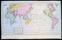
Cartographer : | George Anson | |||||||||||
| Title : | Carte dans laquelle on Voit la Route que le Centurion a Tenu dans la Voiage au tour du Monde | ||||||||||||
| Date : | 1750 | ||||||||||||
| Size : | 16 1/2in x 11in (420mm x 280mm) | ||||||||||||
| Description : |
This finely engraved
beautifully hand coloured original antique World Map -
showing California as an Island - illustrates the route
taken by
Admiral George Anson in his ship the Centurion in his
global voyage of discovery between 1740 & 1744.
In his famous voyage (174044) around the world, Anson,
in spite of shipwrecks and scurvy, inflicted great
damage on Spanish shipping and returned to England with
a rich prize. He was raised to the peerage after his
popular naval victory (1747) off Cape Finisterre.
Appointed then as first lord of the admiralty, he
assisted William Pitt, Lord Chatham, in reorganizing
naval administration.
General Description: Imperfections: |
||||||||||||
| Condition : | (A+) Fine Condition | ||||||||||||
| Price :
Ref. No. : |
|||||||||||||
|
|||||||||||||