|
This large
beautifully hand coloured original antique print of
Capt. James Cooks ships the Resolution and Discovery
anchored in Christmas Bay, Kerguelen Islands on
Christmas day 1776, was engraved by Edward Newton drawn
by John Webber during Cooks 3rd voyage of Discovery. The
print was published in the 1784 1st edition of 'A
Voyage to the Pacific', James Newton, London.
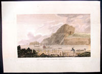
The Resolution and Discovery are anchored in the bay
with two boats putting off, another by the shore to
right and a man in the foreground raising a stick to
kill penguins; a great hill is sited on the opposite
side with a rocky outcrop above, a portion of land
separated from the mainland by a small channel and a
natural stone arch separated from that, in the distance
to left.
These large 1st edition prints were copied many times
over the next 50 years but none rival the expertise and
detail evident in this original print.
John Webber (1752-93) was the official artist on
Cook's final voyage through the Pacific; his drawings
formed the basis for printed illustrations to the
account of the voyage 'A Voyage to the Pacific',
published in 1784.
The Kerguelen Islands, sometimes called the
Desolation Islands, are located in the southern Indian
Ocean and were discovered by the French navigator Yves
de Kerguelen-Trémarec in 1772. On Christmas Day, 1776
Cooks ships Resolution and Discovery anchored in Oiseau
Bay, which he named Christmas Harbour. Cook's men
discovered a bottle containing a message in Latin left
by Kerguelen's men. Cook wrote in his log: I could have
very properly called the island Desolation Island to
signalise its sterility, but in order not to deprive M.
de Kerguelen of the glory of having discovered it, I
have called it Kerguelen Land.
The Kerguelen Islands or the Kerguelen Archipelago are
located in the southern Indian Ocean. The main island,
Grande Terre, is 6,675 km² and it is surrounded by
another 300 smaller islands and islets, forming an
archipelago of 7,215 km². The climate is cold and very
windy and the seas are usually rough. The islands are
part of a submarine large igneous province called the
Kerguelen Plateau.
Cook's Third
Voyage (1776-1779)
In the course of his
first two voyages, Cook circumnavigated the globe twice,
sailed extensively into the Antarctic, and charted
coastlines from Newfoundland to New Zealand. Following
these achievements, Cook's third voyage was organized to
seek an efficient route from England to southern and
eastern Asia that would not entail rounding the Cape of
Good Hope. The search for such a Northwest (or
Northeast) Passage had been on the agenda of northern
European mariners and merchants since the beginning of
European expansion in the late fifteenth century.
England's growing economic and colonial interests in
India in the later eighteenth century provided the
stimulus for the latest exploration for this route.
Cook, again in command
of the Resolution, was to approach the Northwest
Passage from the Pacific accompanied by a second ship,
the Discovery, captained by Charles Clerke. The
ships left England separately, regrouped at Cape Town,
and continued on to Tasmania, New Zealand, and Tahiti.
The expedition then sailed north and made landfall at
Christmas Island and the Hawaiian Islands. Cook
continued northward and charted the west coast of North
America from Northern California as far as the Bering
Strait. He returned to Hawaii for the winter and was
killed in a skirmish with natives on February 14, 1779.
Upon Cook's death, Clerke took command of the expedition
but died six months later. The ships returned to England
in 1780 under John Gore, who had commanded the
Discovery after Cook's death. From start to finish,
the voyage had lasted more than four years.
(Ref Tooley; M&B; Clancy)
General Description:
Paper thickness and
quality: - Heavy and stable
Paper color: - off white
Age of map color: - Early
Colors used: - Green, yellow, blue, red
General color appearance: - Authentic
Paper size: - 20in x 14 1/2in (510mm x 370mm)
Plate size: - 16in x 10 1/2in (410mm x 270mm)
Margins: - 2in (50mm)
Imperfections:
Margins: - Light spotting
Plate area: - Vertical crease along top of image
Verso: - Light soiling |