Search the entire catalogue by entering a key search term in the ‘search’ box or browse our stock by selecting from the list of categories below.
MAPS BRITISH ISLES
![]()
ENGLAND
![]()
|
|||||||||||||
|
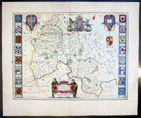
Cartographer : | Joan Blaeu | |||||||||||
| Title : | Oxonium Comitatus, Vulgo Oxfordshire | ||||||||||||
| Date : | 1647 | ||||||||||||
| Size : | 23 1/2in x 19 1/2in (600mm x 495mm) | ||||||||||||
| Description : |
This finely engraved
beautifully hand coloured original antique map of the
English county of Oxfordshire was published in the 1647 Dutch
edition of Joan Blaeus Atlas Novus. There is also the added bonus
on the back of the map with an early depiction of
Stonehenge.
General Description:
Imperfections: |
||||||||||||
| Condition : | (A+) Fine Condition | ||||||||||||
| Price :
Ref. No. : |
|||||||||||||
|
|||||||||||||