|
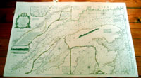
This
very large finely engraved hand coloured original
antique map, a chart of the St Lawrence River, Canada - with
many inset maps and text - by Thomas Jeffery's, was
published by Robert Sayer in 1775, the date is engraved
at the foot of the map.
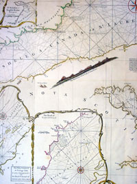
This
is the famous chart of the St. Lawrence River by the
noted eighteenth century English cartographer Thomas
Jefferys, Geographer to George III and the Prince of
Wales.
Jefferys produced many important maps of America from
1751 until 1768, including this superior chart first
issued in 1757.
The main source for Jefferys was a map issued in 1702
based on a survey of the river by Frenchman Jean
Deshayes. Deshayes map became the standard chart of the
St. Lawrence until James Cook's surveys appeared in the
second half of the century. Jefferys translated Deshayes'
chart into English, and added an updated depiction of
the river from Lake Ontario to Quebec based on J.B.B.
D'Anville's 1755 map of Canada.
This is a complete sailing chart, with depth soundings,
rhumb lines for navigation, written directions, and
coastal profiles. The central part of the map shows the
river from Anticosti Island to Quebec, and it includes a
number of insets such as the one based on D'Anville's
map and four others depicting important sections of the
river with greater detail. This reissue of the Jefferys
map, which appeared in his The American Atlas,
was prompted by the growing tensions between the British
government and its colonies, that generated an
increasing demand for maps of North America. The St.
Lawrence River, with its importance to shipping to and
from the prosperous Canadian settlements, was of
particular interest to readers in London and elsewhere
in the English speaking world. (Ref: Tooley; M&B)
General Description:
Paper thickness and quality: - Heavy and stable
Paper color: - off white
Age of map color: - Original
Colors used: - Yellow, pink, green, brown
General color appearance: - Authentic
Paper size: - 38in x 26in (970mm x 660mm)
Plate size: - 37 1/2in x 24in (940mm x 610mm)
Margins: - Min 1/2in (12m)
Imperfections:
Margins: - None
Plate area: - Folds as issued
Verso: - Some cross folds re-enforced with archival tape, no
loss
|