Search the entire catalogue by entering a key search term in the ‘search’ box or browse our stock by selecting from the list of categories below.
MAPS AUSTRALIA/PACIFIC
![]()
![]()
|
|||||||||||||
|
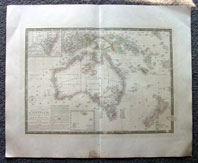
Cartographer : | Adrien Brue | |||||||||||
| Title : | Carte de L'Australie...1826...1834 | ||||||||||||
| Date : | 1826 (1834) | ||||||||||||
| Size : | 26in x 21in (660mm x 535mm) | ||||||||||||
| Description : |
This
large
beautifully engraved hand
coloured original antique
early map
of Australia & New Zealand -
with an inset map of
the colony of New South
Wales - was
engraved in 1826 with
an update in 1834 - dated in
the title - was
published
by
Adrien Brues (1786 - 1832)
in his atlas
Universel de Geographie.
(Ref: M&B; Tooley)
If you wish to discuss this or any other item
General Description:
Imperfections: |
||||||||||||
| Condition : | (A) Very Good Condition | ||||||||||||
| Price :
Ref. No. : |
|||||||||||||
|
|||||||||||||