Search the entire catalogue by entering a key search term in the ‘search’ box or browse our stock by selecting from the list of categories below.
MAPS AMERICA
![]()
NORTH AMERICA
![]()
|
|||||||||||||
|
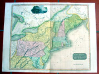
Cartographer : | John Thomson | |||||||||||
| Title : | Northern Provinces of the United States | ||||||||||||
| Date : | 1817 | ||||||||||||
| Size : | 27in x 21in (700mm x 530mm) | ||||||||||||
| Description : |
This large beautifully hand coloured original antique map of the NE Coast of the United States from Chesapeake Bay north to Maine was published by John Thomson in 1817 - dated at the foot of the map - in his large 1817 edition of A New General Atlas of the World. (Ref Tooley M&B)
General Description:
Imperfections:
If you wish to discuss this or any other item |
||||||||||||
| Condition : | (A) Very Good Condition | ||||||||||||
| Price :
Ref. No. : |
|||||||||||||
|
|||||||||||||