|
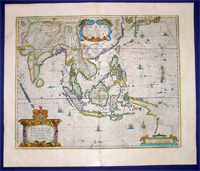
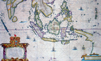
This fine
beautifully hand coloured original antique and
very important map of the East Indies, India, SE Asia,
China, Japan Philippines and Australia - the first to
map the west coast of Cape York Peninsular northern
Queensland as well as parts of the SW coast of Western
Australia, with place names, was published in
the 1639 French edition of Mercators
Atlas by Jan Jansson and Henricus Hondius.
An important Dutch map of South East Asia, noteworthy
for including the discoveries made in New Guinea and
northern Queensland, Australia by the Dutch vessel
Duyfken in 1605-06. Under the command of Willem Janzoon,
the Duyfken explored the eastern shore of the Gulf of
Carpentaria, just below the Cape York Peninsula, a
venture which was famously the first recorded European
contact with Australia.
Background: This map of the East Indies extending from
India to Japan and south to Australia, shows some of the
Dutch discoveries along the West Australian coastline
like the Swan River, Nassau River, Coen River and the
Batavia River borrows heavily from the exact map by Joan
Blaeu. On the eastern part lower right of the
map is a small section of Cape York Peninsular. This
map is one of the first printed maps to show any part of
the Australian coastline. It continued to be an issued
unchanged from 1635 up until the
1660's, long after some of the information it
contained had been superseded. This was despite the fact
that Joan Blaeu as cartographer to the Dutch East India
Company from 1638 to 1673 had access to the latest
information concerning the extension of the Dutch
maritime power in the East Indies, publishing the
results of such discoveries (especially of Australia) on
large World maps, such as that of 1648.
In other words, atlas map's of the East Indies and
part of Australia ignores the results of Abel Tasman's
discoveries made during the voyage of 1642-44. In 1642,
Tasman was appointed commander of an expedition to the
South Seas, during which he discovered the Island later
named after him as well as part of the coast of New
Zealand. His voyage 1644 coasted along the shore of the
Gulf of Carpentaria and along the northern coast of
Australia as far as the Tropic of Capricorn.
Tasman's discoveries were published very soon afterwards
on Blaeu's large World Maps, rendering it all the more
curious that the atlas map was never revised. In affect,
this map remained an historical map of the archipelago,
showing discoveries made. albeit in a rather haphazard
and fortuitous manner by the Dutch, between 1606 and
1623..
The design of the map emphasises the importance of the
commercial interests in the East Indies, centred as it
is on the heart of what was to become The Netherlands
East Indies and later Indonesia. (Ref: Koeman; M&B)
Condition Report
Paper thickness and quality: - Heavy and stable
Paper color: - off white
Age of map color: - Original
Colors used: - Red, yellow, green
General color appearance: - Authentic
Paper size: - 22 1/2in x 19 1/4in (570mm x 485mm)
Plate size: - 19 1/4in x 15 1/2in (485mm x 395mm)
Margins: - Min 1in (25mm)
Imperfections:
Margins: - Light age toning
Plate area: - Light offsetting,
light
age toning
Verso: -
Light age toning
If you wish to discuss this or any other item
please email or call...Simon
61 (0) 409 551910 Tel
simon@classicalimages.com
|