|
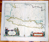
This
large elegant & very impressive hand coloured original antique
map, a sea chart of the Indonesian Island of Java
including Sumatra, Borneo and Bali was published by Jan Jansson in the 1650 Edition of his
"Water World" atlas Atlantis Majoris.
This is a reasonably scarce map with very few available
on the market today. I have 3 records of past sales
since 1983 with a top price of $1550 paid in 1996.
Java & the port of Batavia was at the time of
publication of the utmost importance to the Dutch East
India Company and its domination of the Spice Trade.
This elegant chart focuses on the islands coast with the
lack of detail on the interior correctly reflecting the
lack of knowledge (or possible lack of importance) to
the Dutch, who's primary concern was the sea and sea
charts used in the trade of the ever lucrative Spice
Trade.
The Dutch capital in the East Indies is Batavia
(Jakarta) located on the NW coast. The beautiful chart
is richly embellished with two fine cartouches featuring
local Javanese warrior and Chinese merchants flanking
the title and Neptune and mermaids surrounding the scale
of miles.
The Dutch East
India Company (VOC) was a chartered company
established in 1602, when the States-General of the
Netherlands granted it a 21-year monopoly to carry out
colonial activities in Asia. It was the second
multinational corporation in the world (the British East
India Company was founded two years earlier) and the
first company to issue stock. It was also arguably the
first mega-corporation, possessing quasi-governmental
powers, including the ability to wage war, imprison and
execute convicts, negotiate treaties, coin money, and
establish colonies.
Statistically, the VOC eclipsed all of its rivals in the
Asia trade. Between 1602 and 1796 the VOC sent almost a
million Europeans to work in the Asian trade on 4,785
ships, and netted for their efforts more than 2.5
million tons of Asian trade goods. By contrast, the rest
of Europe combined sent only 882,412 people from 1500 to
1795, and the fleet of the English (later British) East
India Company, the VOCs nearest competitor, was a
distant second to its total traffic with 2,690 ships and
a mere one-fifth the tonnage of goods carried by the
VOC. The VOC enjoyed huge profits from its spice
monopoly through most of the 17th century.
Having been set up in 1602, to profit from the Malukan
spice trade, in 1619 the VOC established a capital in
the port city of Batavia (now Jakarta) on the Indonesian
Island of Java. Over the next two centuries the Company
acquired additional ports as trading bases and
safeguarded their interests by taking over surrounding
territory. It remained an important trading concern and
paid an 18% annual dividend for almost 200 years.
Weighed down by corruption in the late 18th century, the
Company went bankrupt and was formally dissolved in
1800, its possessions and the debt being taken over by
the government of the Dutch Batavian Republic. The VOC's
territories became the Dutch East Indies and were
expanded over the course of the 19th century to include
the whole of the Indonesian archipelago, and in the 20th
century would form Indonesia. (Ref: Tooley, M&B)
General Description:
Paper thickness and
quality: - Heavy and stable
Paper color: - off white
Age of map color: - Original
Colors used: - Green, red, orange, yellow, blue
General color appearance: - Authentic
Paper size: - 23in x 19 1/2in (585mm x 495mm)
Plate size: - 20 1/2in x 16 3/4in (520mm x 425mm)
Margins: - Min 1in (25mm)
Imperfections:
Margins: - Small repair & ink notations
Plate area: - Light creasing
Verso: - None
|