|
This
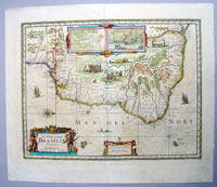
beautifully hand coloured original antique map of Brazil
was engraved by Henricus Hondius and published in the
1639 French edition of Mercators
Atlas by Jan Jansson and Henricus Hondius.
These maps, published in the later editions of
Mercators atlas, are derived from the original maps
drawn and engraved by Gerald Mercator in the mid to late
16th century, published by his son Rumold as an atlas,
after his death, in 1595.
After two editions the plates were purchased by
Jodocus Hondius in 1604 and
continued to be
published until the mid 1630's when the plates were
re-engraved and updated by Jan Jansson and Henricus
Hondius.
Oriented west to the top of the plate, this general map
of Brazil by Jansson is more decorative than the one
published by Joan Blaeu four years earlier but the
topographical details are distinctly Blaeu's. Plagiarism
by these two from each other was by this stage not just
blatant but almost expected.
Dutch attempts to found an
empire in South America began in 1624 with an attack on
Bahia (Salvador), the natural harbour at Bahia d'torres
os Santos. An inset of the bay is included at the top of
the map. The attack was unsuccessful and the Netherlands
West India Company made another successful attempt in
1630, this time at Olinda de Pernambuco (Recife) further
North near the North Eastern most point of Brazil, an
inset is also included of Pernambuco.
At the height of their power in Brazil, when the Dutch
controlled or influenced four of the seven Portuguese
governorships in Brazil under the leadership of Johann
Mauritis Van Nassau-Siegen, much of the trade of
North Eastern Brazil was in the hands of the Company
acting on the assumption that it had the right to trade
- and to make war - with Spain and Portugal in the
Americas.
However the Dutch never quite succeeded in bringing the
Portuguese colonists in the region under their control.
Johan Maurits, during his governorship which lasted from
1637 - 1644, never ceased to warn his superior in the
Netherlands that unless they sent out Protestant
settlers t replace the Roman Catholic Portuguese
settlers, the latter would always remain Portuguese at
heart, and would ultimately revolt against the Dutch at
the earliest opportunity.
Johan Maurits's fears came to pass in 1645, and the
Luso-Dutch war which followed, many senior Dutch
officials who had married Portuguese wives, turned their
allegiances towards Portugal, leading to the final
expulsion of the Dutch from Brazil in 1644.(Ref: Tooley,
Koeman)
Jodocus
Hondius (1563 - 1612), one of the most notable
engravers of his time, is known for his work in
association with many of the cartographers and
publishers prominent at the end of the sixteenth and the
beginning of the seventeenth century.
In 1604
Hondius bought the plates of Mercator's Atlas which, in
spite of its excellence, had not competed successfully
with the continuing demand of Abraham Ortelius's
Theatrum Orbis
Terrarum.
To meet this competition Hondius added about 40 maps to
Mercator's original number and from 1606 published
enlarged editions in many languages, still under
Mercator's name but with his own name as publisher.
These atlases have become known as the Mercator/Hondius
series. The following year the maps were re-engraved in
miniature form and issued as a pocket
Atlas Minor.
After the death of Jodocus Hondius the Elder in 1612,
work on the two atlases, folio and miniature, was
carried on by his widow and sons, Jodocus II and
Henricus, and eventually in conjunction with Jan Jansson
in Amsterdam. In all, from 1606 onwards, nearly 50
editions with increasing numbers of maps with texts in
the main European languages were printed.
(Ref: Koeman; M&B; Tooley)
Condition Report:
Paper
thickness and quality: - Heavy & stable
Paper color: - off white
Age of map color: - Original
Colors used: - Yellow, pink, green
General color appearance: - Authentic
Paper size: - 22 1/2in x 19in (570mm x 490mm)
Plate size: - 19 1/2in x 15 1/2in (490mm x 390mm)
Margins: - Min 1in (25mm)
Imperfections:
Margins: - None
Plate area: - Light creasing
Verso: - None
If you wish to discuss this or any other item
please email or call - good luck, Simon.
Classical Images
61 (0) 409 551910 Tel
simon@classicalimages.com
|