|
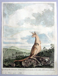
This fine hand
coloured
original antique print of a Kangaroo - after Sydney
Parkinson Captain Cooks artist during his first voyage
on the
Endeavour - was first drawn
during Cook's
survey of the East Coast of Australia in 1770 and was
published in 1784 for the Italian edition of Cooks
voyages.
Cook's First Voyage
(1768-1771)
The first voyage under
Captain James Cook's command was primarily of a
scientific nature. The expedition on the Endeavour
initially sailed to Tahiti to observe the transit of the
planet Venus in order to calculate the earth's distance
from the sun. Cook landed on the South Pacific island in
April of 1769 and in June of that year the astronomical
observations were successfully completed. In addition to
these labors, very good relations with the Tahitians
were maintained and the naturalists Joseph Banks and
Daniel C. Solander conducted extensive ethnological and
botanical research.
Another purpose of the voyage was to explore the South
Seas to determine if an inhabitable continent existed in
the mid-latitudes of the Southern Hemisphere. Upon
leaving Tahiti, Cook named and charted the Society
Islands and then continued southwest to New Zealand. His
circumnavigation and exploration of that country also
resulted in a detailed survey. Cook proceeded to
Australia, where he charted the eastern coast for 2,000
miles, naming the area New South Wales. As a result of
these surveys, both Australia and New Zealand were
annexed by Great Britain. In addition to these
explorations, the Endeavour returned to England
without a single death from scurvy among its men, an
historic feat at the time. The combination of these
accomplishments brought Cook prominence, promotion, and
the opportunity to lead further expeditions.
Cook's Second Voyage (1772-1775)
Based on the success of
his first voyage, Cook was appointed by the Admiralty to
lead a second expedition. Two ships were employed with
Cook commanding the Resolution and Captain Tobias
Furneaux in charge of the Adventure. The purpose
was to circumnavigate the globe as far south as possible
to confirm the location of a southern continent. Cook
proved that there was no "Terra Australis," which
supposedly was located between New Zealand and South
America. Cook was convinced, however, that there was
land beyond the southern ice fields. In his pursuit of
this idea, this expedition was the first European voyage
to cross the Antarctic Circle. In addition, in two great
sweeps through the Southern latitudes, Cook made an
incredible number of landfalls including New Zealand,
Easter Island, the Marquesas, Tahiti and the Society
Islands, the Tonga Islands, the New Hebrides, New
Caledonia, and a number of smaller islands.
In addition to these navigational accomplishments and
the accompanying expansion of geographical knowledge,
the expedition also recorded a vast amount of
information regarding the Pacific islands and peoples,
proved the value of the chronometer as an instrument for
calculating longitude, and improved techniques for
preventing scurvy.
Cook's Third Voyage (1776-1779)
In the course of his first
two voyages, Cook circumnavigated the globe twice,
sailed extensively into the Antarctic, and charted
coastlines from Newfoundland to New Zealand. Following
these achievements, Cook's third voyage was organized to
seek an efficient route from England to southern and
eastern Asia that would not entail rounding the Cape of
Good Hope. The search for such a Northwest (or
Northeast) Passage had been on the agenda of northern
European mariners and merchants since the beginning of
European expansion in the late fifteenth century.
England's growing economic and colonial interests in
India in the later eighteenth century provided the
stimulus for the latest exploration for this route.
Cook, again in command
of the Resolution, was to approach the Northwest
Passage from the Pacific accompanied by a second ship,
the Discovery, captained by Charles Clerke. The
ships left England separately, regrouped at Cape Town,
and continued on to Tasmania, New Zealand, and Tahiti.
The expedition then sailed north and made landfall at
Christmas Island and the Hawaiian Islands. Cook
continued northward and charted the west coast of North
America from Northern California as far as the Bering
Strait. He returned to Hawaii for the winter and was
killed in a skirmish with natives on February 14, 1779.
Upon Cook's death, Clerke took command of the expedition
but died six months later. The ships returned to England
in 1780 under John Gore, who had commanded the
Discovery after Cook's death. From start to finish,
the voyage had lasted more than four years.
(Ref Tooley; M&B; Clancy)
General Description:
Paper thickness and
quality: - Heavy and stable
Paper color: - off white
Age of map color: - Early
Colors used: - Brown, yellow,
General color appearance: - Authentic
Paper size: - 9in x 7in (225mm x 175mm)
Plate size: - 9in x 7in (225mm x 175mm)
Margins: - 1/2in (12mm)
Imperfections:
Margins: - None
Plate area: - None
Verso: - None
If you wish to discuss this or any other item
please email or call - good luck, Simon.
Classical Images
61 (0) 409 551910 Tel
simon@classicalimages.com
|