Search the entire catalogue by entering a key search term in the ‘search’ box or browse our stock by selecting from the list of categories below.
MAPS AMERICA
![]()
NORTH AMERICA
![]()
|
|||||||||||||
|
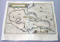
Cartographer : | Jan Jansson | |||||||||||
| Title : | nsulae Americanae in Oceano Septentrionali cum terris adiacentibus | ||||||||||||
| Date : | 1639 | ||||||||||||
| Size : | 22 1/2in x 18 3/4in (570mm x 475mm) | ||||||||||||
| Description : |
This finely engraved
beautifully hand coloured original antique map of Gulf
of Mexico, The Caribbean, Virginia to Florida to Texas
and Central America, Venezuela
was published in the 1639 French edition of Jan Jansson's Atlas Nouvs. Background: Cartographically this map draws on the extremely rare chart by Hessel Gerritsz, c.1631. The area of coverage is exactly the same with the exception of the addition of the west coast of Central America. The nomenclature of the North American part is virtually identical, the only notable addition being the naming of Virginia. It reflects the firsthand knowledge of Gerritsz during his voyage to South America and the West Indies undertaken in 1628. The distance between Chesapeake Bay and Albemarle Sound is accurately portrayed at 1°; even in Gerritsz's acclaimed NOVA ANGLIA ..., for de Laet, 1630, this distance is over 2°. It seems likely that a Spanish chart was used as the nomenclature along the south-east coast lacks any of the French influences often seen at the time.(Ref: Tooley, Koeman) General Description:
If you wish to discuss this or any other item Web Counter |
||||||||||||
| Condition : | (B) Good Condition | ||||||||||||
| Price :
Ref. No. : |
|||||||||||||
|
|||||||||||||