Search the entire catalogue by entering a key search term in the ‘search’ box or browse our stock by selecting from the list of categories below.
MAPS AUSTRALIA/PACIFIC
![]()
![]()
|
|||||||||||||
|
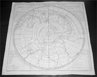
Cartographer : | James Cook | |||||||||||
| Title : | Carte De L ' Hemisphere Austral...Par le Capitaine Jacques Cook. | ||||||||||||
| Date : | 1780 | ||||||||||||
| Size : | 22 1/2in x 22 1/2in (575mm x 575mm) | ||||||||||||
| Description : |
This fine, large original
antique map, a sea-chart of the Southern Hemisphere was engraved by Robert Benard and
published in the 1780 French edition of L'Histoire
Generale des Voyages.
Background: The map is a South
Polar Projection showing South America, the South
Atlantic Ocean, South Africa, Madagascar, Australia - with
Tasmania still joined to the mainland - New Zealand and
the southern Pacific Ocean with islands. Cook was recognized by his contemporaries as a highly
competent navigator and scientific observer. The map
clearly details his departure from the more established
routes crossing the Pacific at a higher latitude, making
it inevitable that he reached New Holland's east coast.
Note the more northerly route taken by Cooks
predecessors through calmer waters, thus missing the
prize of the east coast of Australia.
General
Description:
Imperfections:
If you wish to discuss this or any other item |
||||||||||||
| Condition : | (A+) Fine Condition | ||||||||||||
| Price :
Ref. No. : |
|||||||||||||
|
|||||||||||||