Search the entire catalogue by entering a key search term in the ‘search’ box or browse our stock by selecting from the list of categories below.
MAPS TOWN PLANS
![]()
ITALY
![]()
|
|||||||||||||
|
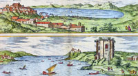
Cartographer : | Braun & Hogenberg | |||||||||||
| Title : | Puteoli et Baiae | ||||||||||||
| Date : | 1575 | ||||||||||||
| Size : | 21in x 16in (535mm x 410mm) | ||||||||||||
| Description : |
This finely engraved beautifully hand coloured original antique 2 x birds-eye view of the Bay of Pozzuoli -in the Gulf of Naples - with The city of Pozzuoli & the Port Of Baia visible was published by Georg Braun & Frans Hogenberg for the 1575 atlas of town plans Civiates Orbis Terrarum Vol II intended as a companion to Abraham Ortelius's master Atlas Theatrum Orbis Terrarum published in 1570. The Gulf of Naples is a 10-mile wide gulf located in the south western coast of Italy, (province of Naples, Campania region). It opens to the west into the Mediterranean Sea & is bordered on the north by the cities of Naples and Pozzuoli. To the east is Mount Vesuvius, and on the south by the Sorrentine Peninsula and its main town Sorrento; the Peninsula separates it from the Gulf of Salerno. Pozzuoli
began as the Greek colony of Dicaearchia. The Roman
colony was established in 194 BC, and took the Latin
name Puteoli 'little wells', referring to the many hot
springs in the area, most notably Solfatara. This is
because Pozzuoli lies in the center of the Campi Flegrei,
a caldera. For a variety of reasons town plans were comparatively latecomers in the long history of cartography. Few cities in Europe in the middle ages had more than 20,00 inhabitants and even London in the late Elizabethan period had only 100-150,000 people which in itself was probably 10 times that of any other English city. The Nuremberg Chronicle in 1493 included one of the first town views of Jerusalem, thereafter, for most of the sixteenth century, German cartographers led the way in producing town plans in a modern sense. In 1544 Sebastian Munster issued in Basle his Cosmographia containing roughly sixty-six plans and views, some in the plan form, but many in the old panorama or birds eye view. (Ref: Tooley; M&B)
Condition Report:
Imperfections: | ||||||||||||