Search the entire catalogue by entering a key search term in the ‘search’ box or browse our stock by selecting from the list of categories below.
MAPS AMERICA
![]()
![]()
|
|||||||||||||
|
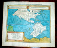
Cartographer : | Sebastian Munster | |||||||||||
| Title : | Americæ Sive Novi Orbis, Nova Descriptio. / Die newen Inseln / so hinder Hispania gegen Orient | ||||||||||||
| Date : | 1588 | ||||||||||||
| Size : | 16 1/2in x 14 1/2in (420mm x 355mm) | ||||||||||||
| Description : |
By the mid 1580's Sebastian Munster's maps contained
within the first recognisable "modern" Atlas
Cosmographia were becoming dated and redundant.
In 1588 this beautifully hand coloured original antique map of
America - The New world - was published in the
revised edition of Cosmographia published by Sebastian
Petri, Basle. Within this map - which is directly based on Ortelius's 1570 1st edition - there is the depiction of discoveries of a number of people, but the general shape is derived from Gerard Mercator's great twenty one sheet world map published in 1569. Ortelius and Mercator had a close relationship and regularly shared openly with each other. One of the main features of this map is the bulbous Chilean coastline; which was not corrected by Ortelius until 1587, although Munster obviously did not have access to this new plate still showing the bulging coast in this 1588 edition. As with the Ortelius map Munster has strategically placed the bottom cartouche hiding the lack of knowledge of the southern waters of the South Pacific. Once through the Straits of Magellan the voyagers sea route took him on an almost direct course for the east Indies. No sight has been made of a large continent but conventional wisdom had it that has to be as much land in the southern hemisphere as in the northern. this was not fully dispelled until the second voyage of the remarkable Captain James Cook in 1772-75. The west coast of North America is shown too far west, as was common at the time. Sebastian Petri re-release of Cosomgraphia in 1588 produced some fine woodcut maps in the "copperplate style". The maps in this release were more sophisticated than with earlier publications of Cosomgraphia and were based on the 1570 release of Abraham Ortelius monumental work Theatrum Orbis Terrarum. (Ref: Burden; M&B; Tooley) General Description: |
||||||||||||
| Condition : | (A+) Fine Condition | ||||||||||||
| Price :
Ref. No. : |
|||||||||||||
|
|||||||||||||