Search the entire catalogue by entering a key search term in the ‘search’ box or browse our stock by selecting from the list of categories below.
MAPS AMERICA
![]()
NORTH AMERICA
![]()
|
||||||||||
|
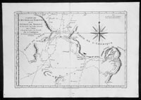
Cartographer : | James Cook | ||||||||
| Title : | Carte De L Entree De Norton et Du Detroit de Bhering..Par M Bonne.... | |||||||||
| Date : | 1780 | |||||||||
| Size : | 16 1/2in x 11 1/2in (420mm x 290mm) | |||||||||
| Description : |
This finely engraved original antique map
of Capt James Cooks discoveries, surveys and depth soundings in the Bering
Straits between Seward Peninsular & Norton Sound in Alaska and Chukotskiy
Poluostrov Peninsula in Siberia Russia by Rigobert Bonne was published in the
1778 edition of Atllas des toutes les parties connues du globe terrestre
by Guillaume Raynal.
(Ref: Tooley; M&B) General Description: |
|||||||||
| Condition : | (A+) Fine Condition | |||||||||
| Price :
Ref. No. : |
||||||||||
|
||||||||||