Search the entire catalogue by entering a key search term in the ‘search’ box or browse our stock by selecting from the list of categories below.
MAPS ASIA
![]()
INDONESIA
![]()
|
|||||||||||||
|
Cartographer : | Depot de la Marine | |||||||||||
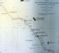
| Title : | Carte de la Cote Occidentale De Sumatra..1837 | ||||||||||||
| Date : | 1837 | ||||||||||||
| Size : | 38in x 26 1/2in (330mm x 255mm) | ||||||||||||
| Description : |
This very large finely engraved and
highly detailed sea chart map of the west coast of
Sumatra - with inset maps of 5 different harbour points
- was engraved in 1837 - the date is engraved in the
title - and was published by The French Admiralty -
General Description:
Imperfections: |
||||||||||||
| Condition : | (A+) Fine Condition | ||||||||||||
| Price :
Ref. No. : |
|||||||||||||
|
|||||||||||||