Search the entire catalogue by entering a key search term in the ‘search’ box or browse our stock by selecting from the list of categories below.
MAPS BRITISH ISLES
![]()
![]()
|
|||||||||||||
|
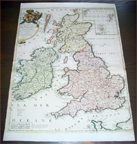
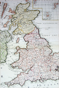
Cartographer : | J B Nolin | |||||||||||
| Title : | Les Isles Britanniques ou sont Les Royaumes d Angleterre d Escosse et d Irlande...J B Nolin | ||||||||||||
| Date : | 1707 | ||||||||||||
| Size : | 26in x 19 1/2in (660mm x 495mm) | ||||||||||||
| Description : |
This large beautifully
hand coloured original antique map of Great Britain & Ireland was
published by J.B. Nolin in 1707 after the great Italian
cartographer Vincenzo Coronelli. English Cartography:
When considering the work of English map makers we tend,
perhaps, to think too much in terms of county maps,
dominated by the names of Saxton and Speed, but we
should not underrate the contribution to the sum of
geographical knowledge made in other spheres, such as
the sea charts of Edward Wright, Robert Dudley and
Greenvile Collins, the discoveries of James Cook, the
road maps of Ogilby and Cary, the meteorological and
magnetic charts compiled by Edmund Halley, to mention
only a few. In 1558 Queen Elizabeth
came to the throne in the midst of a fast changing
world. In 1563 a nineteen sheet map, copies of which
survive only in manuscript form, was completed by
Laurence Nowell, and no doubt, the issue of Mercator's
large-scale map of the British Isles in 1564 had an
important influence on the thought of the period. A few
years later a national survey was commissioned
privately, although probably at the instigation of Lord
Burghley, the Lord Treasurer, but subsequently was
completed with royal encouragement. The outcome was
Christopher Saxton's Atlas of EngIand and Wales,
started about 1570 and published in 1579 - the first
printed set of county maps and the first countrywide
atlas on such a splendid scale produced anywhere. A
Welsh antiquarian, Humphrey Lhuyd completed a set of
surveys that were even more successful than Saxton in
which he had produced fine manuscript maps of England
and Wales which were used by Ortelius in editions of his
Atlas from 1573 onwards. The earliest maps of
the 17th century, attributed to William Smith of the
College of Heralds, covered only twelve counties based
on Saxton/Norden and were presumably intended to be part
of a complete new atlas. They were printed in the Low
Countries in 1602-3 and were soon followed by maps for
the Latin edition of Camden's Britannia dated
1607. In 1610-11 the first edition of John Speed's
famous county Atlas The Theatre of the Empire of
Great Britaine was published and immediately
replaced Saxton's in popular appeal. Although Speed
assembled much of his material from the earlier works of
Saxton, Norden and others, a considerable part of the
up-to-date information, especially relating to the inset
town plans depicted on his maps, was obtained first
hand. The maps undoubtedly owed much of their popularity
to the splendid engravings of high quality made in the
workshops in Amsterdam of Jodocus Hondius to whom Speed
sent his manuscripts, the plates subsequently being
returned to London for printing. At the beginning of the
eighteenth century the Dutch map trade was finally in
decline, the French in the ascendant and the English to
a great extent still dominated by Saxton and Speed
except, as we have shown, in the spheres of sea charts
and road maps. There were atlases by John Senex, the
Bowles family, Emanuel and Thomas Bowen, Thomas
Badeslade and the unique bird's-eye perspective views of
the counties, The British Monarchy by George
Bickham. In 1750-60 Bowen and Kitchin's The Large
English Atlas containing maps on a rather larger
scale than hitherto was published. General Description: Imperfections:
If you wish to discuss this or any other item |
||||||||||||
| Condition : | (A) Very Good Condition | ||||||||||||
| Price :
Ref. No. : |
|||||||||||||
|
|||||||||||||