|
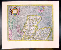
This finely engraved hand coloured original
copper-plate
map of central and Northern Scotland was
published in the 1633 French edition of Mercators Atlas published by Henricus
Hondius and Jan Jansson.
As the Blaeu & Jansson
production of Atlases during the 17th century were so tied together the history
of mapping of the British Isles is closely linked between the two masters.
When the Blaeu's published Volume five of his Atlas Novus in 1654, Scotland
became one of the best-mapped countries in the world. The volume contained
forty-eight plates showing forty-nine separate maps of Scotland (plus a map of
Ptolemy British Isles and six maps of Ireland). The first two plates from the
atlas show the entire country ancient and modern, whilst the remaining forty-six
plates cover most Scotland in forty-seven regional maps. In total the regional
maps locate some 20,000 different place names. A clue as to the reason for this
extraordinary explosion of geographical information is to be found on thirty-six
of the regional maps, which all carry engraved credits to Timothy Pont
(1524-1606)
Pont was responsible for surveying the greater part of Scotland between
1583-1600, the resulting Pont Manuscript maps were never published but were put
to good use some fifty to seventy years later by Robert Gordon and Joan Blaeu.
(Ref: Koeman; Tooley)
Condition Report:
Paper thickness
and quality: - Heavy and stable
Paper color: - off white
Age of map color: - Original
Colors used: - Yellow, pink, green
General color appearance: - Authentic
Paper size: - 22in x 18in (560mm x 460mm)
Plate size: - 18in x 14in (460mm x 355mm)
Margins: - Min 1in (25mm)
Imperfections:
Margins: - None
Plate area: - None
Verso: - None
|