Search the entire catalogue by entering a key search term in the ‘search’ box or browse our stock by selecting from the list of categories below.
MAPS WORLD
![]()
![]()
|
|||||||||||||
|
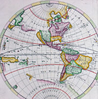
Cartographer : | Nicolas Sanson | |||||||||||
| Title : | Mappe-Monde ou Carte Generale du Globe Terrestre Represntee en Duex Plan Hemispheres...1678 | ||||||||||||
| Date : | 1678 | ||||||||||||
| Size : | 23 1/2in x 17 1/2in (600mm x 445mm) | ||||||||||||
| Description : |
This large beautifully hand coloured original
antique Twin Hemisphere World Map was
engraved by Pierre Mariette and published by Guillaume Sanson in
1678 - dated.
General
Description:
Imperfections: |
||||||||||||
| Condition : | (A) Very Good Condition | ||||||||||||
| Price :
Ref. No. : |
|||||||||||||
|
|||||||||||||