Search the entire catalogue by entering a key search term in the ‘search’ box or browse our stock by selecting from the list of categories below.
MAPS ASIA
![]()
INDONESIA
![]()
|
|||||||||||||
|
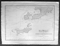
Cartographer : | Louis Freycinet | |||||||||||
| Title : | Carte Particuliere des Detroits De Rottie et de Simao...L Freycienet...le Casuarina 1803. | ||||||||||||
| Date : | 1803 | ||||||||||||
| Size : | 22 1/2in x 16 1/2in (570mm x 420mm) | ||||||||||||
| Description : |
This large beautifully engraved
original antique map of the western peninsular of West
Timor and the island of Rote and West Timor's biggest
city Cupang (Kupang)
Louis Claude Desaulces
de Freycinet (1779-1842) was a French marine officer and
explorer, who participated in several significant early
19th-century expeditions to relatively unknown areas in
the southern hemisphere. In 1800, he joined one of the
most important early explorations of Australia, which
was commissioned by the French government and commanded
by Nicholas Baudin (1754-1803). On this voyage, which
included stops in Mauritius and Tasmania, Freycinet
served as a surveyor and was responsible for conducting
a thorough cartographic survey of the Australian coast.
Upon returning to France years later, he completed a
detailed account of the journey begun by the naturalist
Françis Péron that was published as Voyage de
decouvertes aux Terres Australes between 1807 and
1816. General
Description:
If you wish to discuss this or any other item |
||||||||||||
| Condition : | (A+) Fine Condition | ||||||||||||
| Price :
Ref. No. : |
|||||||||||||
|
|||||||||||||