Search the entire catalogue by entering a key search term in the ‘search’ box or browse our stock by selecting from the list of categories below.
MAPS AFRICA
![]()
![]()
|
|||||||||||||
|
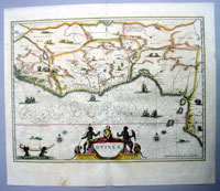
Cartographer : | Jan Jansson | |||||||||||
| Title : | Guinea | ||||||||||||
| Date : | 1639 | ||||||||||||
| Size : | 22 1/2in x 19in (570mm x 490mm) | ||||||||||||
| Description : |
This finely engraved
beautifully hand coloured original antique map of West
Africa - from Sierra Leone to Nigeria -
was engraved by Jan Jansson and was published in the
1639 French edition of Mercators
Atlas by Jan Jansson and Henricus Hondius. Background:
Being part
of the Mediterranean world, the northern coasts of the
African continent as far as the Straits of Gibraltar and
even round to the area of the Fortunate Isles (the
Canaries) were reasonably well known and quite
accurately mapped from ancient times. In particular,
Egypt and the Nile Valley were well defined and the Nile
itself was, of course, one of the rivers separating the
continents in medieval T-O maps. Through Arab traders
the shape of the east coast, down the Red Sea as far as
the equator, was also known but detail shown in the
interior faded into deserts with occasional mountain
ranges and mythical rivers. The southern part of the
continent, in the Ptolemaic tradition, was assumed to
curve to the east to form a land-locked Indian Ocean.
The voyages of the Portuguese, organized by Henry the
Navigator in the fifteenth century, completely changed
the picture and by the end of the century Vasco da Gama
had rounded the Cape enabling cartographers to draw a
quite presentable coastal outline of the whole
continent, even if the interior was to remain largely
unknown for the next two or three centuries. General Description:
If you wish to discuss this or any other item |
||||||||||||
| Condition : | (A+) Fine Condition | ||||||||||||
| Price :
Ref. No. : |
|||||||||||||
|
|||||||||||||