Search the entire catalogue by entering a key search term in the ‘search’ box or browse our stock by selecting from the list of categories below.
MAPS ASIA
![]()
JAPAN
![]()
|
|||||||||||||
|
Cartographer : | Tokugawa Period | |||||||||||
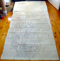
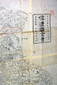
| Title : | Shinano no Kuni Zenzu (Complete map of Shinano no Kuni - Shinano Province: Nagano Prefecture | ||||||||||||
| Date : | 1800 | ||||||||||||
| Size : | 78in x 38in (2.0m x 975mm) | ||||||||||||
| Description : |
This is a wonderful
and unique opportunity to acquire an incredibly rare
piece of original antique Japanese cartography (a
limited printing of less than 100). This extremely large
(over 2m) beautiful wood-block hand coloured map of the
old Shinano Province now today's Nagano Prefecture was
published in the latter part of the Tokugawa Period
sometime at the end of the 18th or early 19th centuries
by Takashiba Mitsuo? Nagano Prefecture - formerly
known as the province of Shinano, and was divided among
many local daimyo during the Sengoku period. Japanese maps are well
known for their exceptional beauty and high quality of
workmanship. Early Japanese cartography has its own very
distinctive projection and layout system. Japanese maps
made prior to the appearance of Commodore Perry and the
opening of Japan in the mid to late 1750s often have no
firm directional orientation, incorporate views into the
map proper, and tend to be hand coloured woodblock
prints.
General Description: Imperfections: |
||||||||||||
| Condition : | (A+) Fine Condition | ||||||||||||
| Price :
Ref. No. : |
|||||||||||||
|
|||||||||||||