|
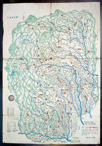
This is a unique
opportunity to acquire an original & rare piece of
antique Japanese cartography. This beautiful wood-block
hand coloured map of the old Shimotsuke province today
the Tochigi Prefecture was published in the late
Tokokawa Period ca 1840 by Akiyama Einen.
Although the early 19th century is not considered that
old in cartographical terms but it is the high level of
artistry & detail that makes these wood-block cut maps
unique. I doubt that there is another map from this
publisher or illustrator available on the market. There
is a level of patience, workmanship & detail about this
map that epitomises many parts of the Japanese culture.
Tochigi Prefecture - Prior to the
establishment of the present-day system of prefectures,
Tochigi was known as the Shimotsuke Province. The
establishment of the Nikko Toshogu in 1617 brought Nikko
to national attention. The Tokugawa Shogunate developed
the Nikko kaido (part of the major road connecting Nikko
with Edo) and required lavish processions to worship
Ieyasu, the founder of the Tokugawa line of shoguns.
In the late 7th century, Tochigi formed Shimotsuke
Province.
During that time was built the Shimotsuke-Yakushi
temple, making it the Buddhist capital of the Kanto
Region. In the early 15th century, Ashikaga University,
Japan's oldest school of higher education, was
re-established, holding over 3000 students by the 16th
century. Saint Francis Xavier introduced Ashikaga to the
world as the best university in Japan.
In the early 17th century, Japan was unified by the
Shogun Tokugawa Ieyasu. After his death, Toshogu was
built in Nikko on what the shoguns thought of as holy
ground to protect and worship Ieyasu. The establishment
of the Nikkō Toshogu in 1617 brought Nikkō to national
attention. The Tokugawa Shogunate developed the Nikkō
Kaidō (part of the major road connecting Nikkō with Edo)
and required lavish processions to worship Ieyasu, the
founder of the Tokugawa line of shoguns.
In the late 19th century the Tokugawa Shogunate fell and
the new government established the prefectures. The
prefectural capital was established in the city of
Tochigi after the unification of Utsunomiya Prefecture
and Tochigi Prefecture in 1873.By 1884, however, the
capital was transferred to Utsunomiya.
Japanese maps are well
known for their exceptional beauty and high quality of
workmanship. Early Japanese cartography has its own very
distinctive projection and layout system. Japanese maps
made prior to the appearance of Commodore Perry and the
opening of Japan in the mid to late 1750s often have no
firm directional orientation, incorporate views into the
map proper, and tend to be hand coloured woodblock
prints.
Later Japanese maps, produced in the late Edo and
throughout the Meiji period (early to mid 19th century)
draw heavily upon western maps as models for their own
work. While many of these later maps maintain elements
of traditional Japanese cartography such as the use of
rice paper, woodblock printing, and delicate hand color,
they also incorporate western directional orientation,
projection systems, and structural norms.
As early as the 7th century AD the Japanese acquired
knowledge of surveying and map engraving through their
cultural links with Korea and China: their earliest
surviving map dates from the 14th century. The first
uncertain attempts to show Japan on European maps were
not made until the mid 15th century (Fra Mauro, 1459)
and even in 1540 Munsters map of the New World still
show "zipangu". Jesuit influence in the early days were
responsible for any data collected about Japan at this
time. From 1640 Japan closed its frontiers (except for
the Port of Nagasaki) to the "barbarians" from the West
and consequently there was little opportunity for
compiling data for accurate mapping. It was not until
the 18th century that maps by Valck, de Vaugondy and
others started to show a better outline of the country,
even incorporating Japanese characters into the images.
(Ref: M&B;
Tooley)
General Description:
Paper thickness and quality: - Very light & stable
Paper color: - Off white
Age of map color: - Original
Colors used: - Blue, yellow, red, green
General color appearance: - Authentic
Paper size: - 21in x 14 1/2in
(535mm x 370mm)
Margins: - Min 1/4in (5mm)
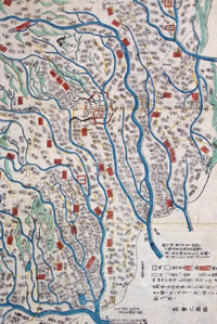
Imperfections:
Margins: - Light wear
Plate area: - Folds as issued, light wear along folds,
several small worm tracks in 10 places on image
Verso: - Light age toning
|