|
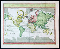
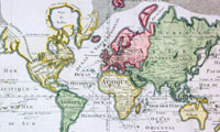
This
fine hand coloured original antique
World map on
Mercators Projection showing the tracks of the French
explorer Viscount Pierre Marie Francois de Pages by
Robert Benard was engraved in 1782 by JBL Aubert - the
date is engraved in the titile - and was published in Le
Pages book Voyage autour du monde et vers les
deux poles, par terra et par mar, pendant les annees
1767 a 1776.
Pages, Pierre Marie Francois, Viscount de, French
explorer, born in Toulouse in 1748; died in Santo
Domingo in 1793. He entered the navy as midshipman in
1764, was promoted to 2nd lieutenant, and in 1767 lead
an expedition to search for the northwest passage by the
eastern coast of Asia. He sailed from Cape Francais, in
Santo Domingo, on 30 June, 1767, and, although he was
unsuccessful in his object, he explored Louisiana,
Texas, Mexico, and the East Indies, returning to
Marseilles, 5 September, 1771.
After some difficulties he was reinstated in the navy on
9 March, 1772. During the following year he took part in
the expedition of Kerguelen to the South sea.
In 1776 he engaged passage on a whaler and visited
Spitzbergen and the coast of Greenland, being the first
navigator to reach 80º 30' north latitude. After being
imprisoned twice by ice-fields he reached Amsterdam on
15 August, 1777. The fatigues and hardships that he
experienced during the journey having impaired his
health, he retired from the navy in 1782 and, going to
Santo Domingo, settled upon an estate that belonged to
his wife, a creole.
His last years were devoted to scientific researches,
and he had in preparation several important works on
America when he died in 1793 among the first victims of
the negro insurgents.
Pages was a member of many learned societies, and in 1782 was created a
knight of St. Louis. He published " Observations sur
l'histoire naturelle, la temperature, les mceurs,
l'industrie et les habitants du royaume de la Nouvelle
Espagne" (2 vols., Paris, 1772); "Memoire sur l'anomalie
de la constitution atmospherique des deux poles" (1775);
" Voyage autour du monde et vers les deux poles, par
terra et par mar, pendant les annees 1767 a 1776" (2
vols., 1782; translated into Dutch, Rotterdam, 1784"
German, Leipsie, 1786; Swedish, Upsala, 1788" and
English, London, 1791, and Boston, 1793) ; and
"Reflexions sur les vents d'est qui regnent entre les
tropiques, sur les pluies et le ciel serein darts ce
paralldle etles circonvoisins"
(Ref:
M&B; Tooley)
General Description:
Paper thickness and quality: - Heavy & stable
Paper color: - White
Age of map color: - Early
Colors used: - Blue, brown
General color appearance: - Authentic
Paper size: - 14 3/4in x 12 1/2in (375mm x
315mm)
Paper size: - 14in x 11 1/2in (355mm x
295mm)
Margins: - Min 1/2in (12mm)
Imperfections:
Margins: - None
Plate area: - Light creasing along folds as issued
Verso: - None
|