|
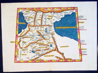
This beautifully hand coloured original antique Ptolemaic map of
the
Caucasus or Caucas
region of central Asia - straddling the
Black & Caspian Seas - was published by Laurent Fries in the 1541
Vienna edition of Ptolemy's Geographia.
Fries is responsible for publishing three editions of
Geographia, with approx. 50 maps, in 1522, 1535 &
1541 after Waldseemullers translation of Ptolemys
Geographia first published in 1513.
This map is in superb condition, the paper is a fresh as
the day it was published.
Caucasus - located
on the peripheries of Turkey, Iran & Russia the region
has been an arena for political, military, religious,
and cultural rivalries and expansionism for centuries.
Ancient kingdoms of the region included Armenia,
Albania, Colchis & Iberia among others.
By the
time of this fourth printing, both Fries and the original printer, Johann Grüninger had died, and the wood-blocks had found their
way into the ownership of Melchior and Gaspar Trechsel.
For this edition, the
brothers employed Michael Servetus (burned at the stake
for Heresy in 1553 due to derogatory comments in this
atlas re: Palestine) to re-edit the text written by
Wilibald Pirckheimer for the 1525, edition.
As a result, the text is completely reset when compared
with other editions.
The geographical area
of each of the maps is unchanged from the previous
editions. There are variations, however, outside the
borders. Titles, where present, are printed from type
set within separate woodcut banners fixed to the upper
border of the block.
The atlas was not re-printed, perhaps in face of
competition from Sebastian Munster's edition of 1540,
which achieved wide popularity, with its enlarged and
improved section of modern maps including, for the first
time, a set of maps of the four known continents.
Claude Ptolemy
- a
Greek mathematician, astronomer and geographer, living
in Alexandria, assembled and codified his predecessors'
cartographic theories including those of Strabo &
Marinus of Tyre (c. AD 120) to whom he was
especially indebted. In about AD 150 he published his
Geographia, a work in 8 volumes, supposedly
illustrated with a world map, 26 regional maps and a
profusion of smaller maps. Although the text of the
Geographia survived, no maps older than about the
twelfth century have come down to us and, in
consequence, we have no means of knowing whether the
'Ptolemy' maps on which we set so much store were, in
fact, drawn by him or were the interpretations of later
map makers using his text as a basis.
In Europe
the initial awakening of interest in geography arose
from the revival of knowledge of Ptolemy's Geographia
soon after the year 1400. Greek manuscript copies
made in the twelfth to fourteenth centuries were brought
by scholars to Italy from Constantinople and were
subsequently translated into Latin and widely studied.
This work coincided with, and was much influenced by,
the development of printing techniques, particularly, of
course, by the invention of movable-type printing by
Gutenberg about 1450, which made possible for the first
time the production of printed books in quantity. Apart
from this factor, other more far-reaching influences
were compelling the peoples of Western Europe to look
beyond the horizon they had known for so many centuries.
With the conquest of Constantinople in 1453 the Turks
effectively closed Europe's trade routes to the East and
shut off access to traditional sources of luxuries and
precious metals from Asia and, above all, denied the
supply of the spices which had become so important in
the lives of ordinary people. Other factors often based
on long-believed myths and legends added to the urge to
break out into the unknown world.
The interpretation of Ptolemy's text began mainly with
the Italians Angelus, Beroaldus & Vadius in 1477 and was
re-interpreted and re-issued by many over the next
century by the likes Waldseemuller 1513, Gastaldi 1548,
Mercator 1578 & Magini 1596. (Ref: Tooley; M&B;
Dover)
General Description:
Paper thickness and quality: - Heavy and stable
Paper color: - off white
Age of map color: - Early
Colors used: - Yellow, green, red, blue.
General color appearance: - Authentic and fresh
Paper size: - 20 1/2in x 15in (520mm x 380mm)
Plate size: - 20 1/2in x 15in (520mm x 380mm)
Margins: - Min 1in (25mm)
Imperfections:
Margins: - None
Plate area: - None
Verso: - None
|