Search the entire catalogue by entering a key search term in the ‘search’ box or browse our stock by selecting from the list of categories below.
MAPS WESTERN EUROPE
![]()
FRANCE
![]()
|
|||||||||||||
|
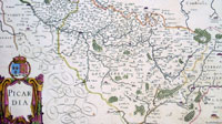
Cartographer : | Jan Jansson | |||||||||||
| Title : | Picardia | ||||||||||||
| Date : | 1638 | ||||||||||||
| Size : | 23 1/2in x 20in (600mm x 510mm) | ||||||||||||
| Description : |
This fine large beautifully hand coloured original antique map of the northern French region of Picardy was published by Jan Jansson in the 1638 edition of Atlas Novus. The map centers on the city of Amiens. (Ref Tooley M&B) General Description: |
||||||||||||
| Condition : | (A+) Fine Condition | ||||||||||||
| Price :
Ref. No. : |
|||||||||||||
|
|||||||||||||