Search the entire catalogue by entering a key search term in the ‘search’ box or browse our stock by selecting from the list of categories below.
MAPS WESTERN EUROPE
![]()
![]()
|
|||||||||||||
|
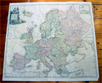
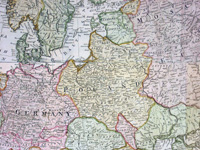
Cartographer : | Thomas Kitchin | |||||||||||
| Title : | A Correct Map of Europe Divided into its Kingdoms & Drawn from the Most approved Maps... | ||||||||||||
| Date : | 1766 | ||||||||||||
| Size : | 32in x 29in (815m x 735mm) | ||||||||||||
| Description : |
This very large beautifully hand
coloured original antique map of Europe by the famous
English cartographer Thomas Kitchin was published by in Malachy Postlethweyt's 2 Volumes publication of
Dictionary of Trade & Commerce published
between 1751 &
1774, this map is from the 1766 edition.
Dictionary of Trade & Commerce
- A monumental dictionary of trade and commerce. It
is based in part on the Dictionnaire universel de
Commerce (Paris: 1723-30) of Jacques Savary de Bruslon,
under whose name it is often catalogued, but has been
adapted by Postlethwayt for a British audience, with
substantial enlargements and improvements, and entirely
new matterial relating to England and her colonies.
Postlethwayt devoted twenty years to the preparation of
the dictionary, which was first published in 1751-55 &
includes a description of British affairs in North
America since the peace of 1763. General Description: Imperfections: |
||||||||||||
| Condition : | (A+) Fine Condition | ||||||||||||
| Price :
Ref. No. : |
|||||||||||||
|
|||||||||||||