Search the entire catalogue by entering a key search term in the ‘search’ box or browse our stock by selecting from the list of categories below.
MAPS TOWN PLANS
![]()
BELGIUM
![]()
|
|||||||||||||
|
Cartographer : | Braun & Hogenberg | |||||||||||
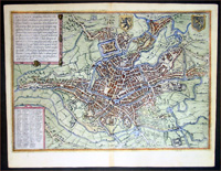
| Title : | Gandavum | ||||||||||||
| Date : | 1575 | ||||||||||||
| Size : | 20in x 15 1/2in (510mm x 395mm) | ||||||||||||
| Description : |
This fine beautifully hand coloured original antique map a birds-eye view of the city Ghent in the East Flanders region of Belgium was published by Georg Braun & Frans Hogenberg for the 1575 atlas of town plans Civiates Orbis Terrarum Vol II (1572-1612) intended as a companion to Abraham Ortelius's master Atlas Theatrum Orbis Terrarum published in 1570. Translation of
the Cartouche Text: Ghent, the most splendid city in
Flanders, was founded by Julius Caesar and called Gaius
after his forename, as the Brabant chroniclers relate.
The city is distinguished by its rivers, altogether
delightful, magnificent, spacious, never confined,
nowhere stifling. The houses are innumerable and
well-kept, the men richly talented, the customs
venerable. A double wall amplifies the beautiful
appearance of the place, which - like Louvain - also has
quiet corners for reflection and study. Ghent also
possesses famous schools and magnificent churches; the
climate is excellent. The people, it can be said, are
more frugal than parsimonious. Ghent is embellished by
the relics of several saints and two famous monasteries
dedicated to St Peter, Prince of the Apostles, and St
Bavo; each has an abbot and a sizeable annual rental
income.
Background of Civitates
Orbis Terrarum For a variety of reasons town plans were comparatively latecomers in the long history of cartography. Few cities in Europe in the middle ages had more than 20,00 inhabitants and even London in the late Elizabethan period had only 100-150,000 people which in itself was probably 10 times that of any other English city. The Nuremberg Chronicle in 1493 included one of the first town views of Jerusalem, thereafter, for most of the sixteenth century, German cartographers led the way in producing town plans in a modern sense. In 1544 Sebastian Munster issued in Basle his Cosmographia containing roughly sixty-six plans and views, some in the plan form, but many in the old panorama or birds eye view. (Ref: Tooley; M&B)
Condition Report:
Imperfections: | ||||||||||||