GO! View Basket

Search the entire catalogue by entering a key search term in the ‘search’ box or browse our stock by selecting from the list of categories below.

MAPS AUSTRALIA/PACIFIC

NEW ZEALAND

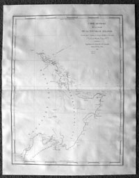
Antique Map of New Zealand by D Urville (42011)
VIEW ITEM / MORE INFO
Cartographer : Jules Sébastien César Dumont D'Urville
Title : Carte Generale de la Partie De La Nouvelle Zelande...D'Urville...1827
Date : 1827
Size : 26in x 20in (660mm x 510mm)
Description :

This large finely engraved original antique map of the North Island of New Zealand was engraved in 1827 - dated - and was published in the 1833 edition of Dumont d'Urville Voyage de la corvette l'Astrolabe.
Fine early chart of New Zealand's north island and parts of the south island, showing the  1827 track of the voyages around the island of the Astrolabe. Only the coastlines surveyed during this voyage and explored are noted. Dumont d'Urville was a French navigator who led an important expedition to the Pacific aboard the Astrolabe (named in memory of La Perouse's flagship) and made significant contributions to the mapping of New Zealand. This chart was made in conjunction with Victor Charles Lottin.

Jules Sébastien César Dumont d'Urville (1790–1842) - was born on 23 May 1790 at Condé-sur-Noireau, a village in Normandy, France. His father was Gabriel François Dumont, sieur of Urville and an hereditary Judge; his mother, née Jeanne de Croisilles, was of a noble French family.
The d'Urvilles, because of their aristocratic connections, took refuge after the French Revolution in a secluded part of Normandy. Here, after the death of his father, Jules was educated by his mother's brother, a churchman of wide learning. Later he attended the Lycée Malherbe at Caen. In 1807 he entered the Navy. A student by talent and inclination, he devoted himself to learning, both in the humanities and natural sciences. In 1815 he married. In 1820, while on a visit in a French naval vessel to the eastern Mediterranean, he was instrumental in procuring for France a Greek statue which had been found on Melos – the Venus de Milo.

In 1822–25, while serving on the Coquille, he surveyed the Falklands, Tahiti and other Pacific islands, and New Holland (W Australia). In 1826–29 he commanded the Astrolabe in a voyage around the world; searching for the ill-fated La Pérouse expedition, he explored Fiji and many other islands of Oceania, the New Zealand coast, and the Moluccas. With the Astrolabe and the Zelée he made a second circumnavigation in 1837–40, and in 1840 he penetrated the ice pack south of New Zealand and discovered the Adélie Coast region in Antarctica. (Ref: M&B; Tooley)

General Description:
Paper thickness and quality: - Heavy
Paper color: - White
Age of map color: - 
Colors used: - 
General color appearance: -  
Paper size: - 26in x 20in (660mm x 510mm)
Plate size: - 26in x 20in (660mm x 510mm)
Margins: - Min 1in (25mm)

Imperfections:
Margins: - None
Plate area: - None
Verso: -
None

If you wish to discuss this or any other item
please email or call - good luck, Simon.
Classical Images
61 (0) 409 551910 Tel


Condition : (A+) Fine Condition

Price :

Ref. No. :

US$750.00

42011

add to basket

payment
shipping
ask a question