Search the entire catalogue by entering a key search term in the ‘search’ box or browse our stock by selecting from the list of categories below.
MAPS ASIA
![]()
INDIA
![]()
|
|||||||||||||
|
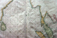
Cartographer : | Jean Baptiste De Mannevillette | |||||||||||
| Title : | Carte Reduite du Golfe de Bengale, depuis L'Isle de Ceyland jusqu'au Golfe de Siam | ||||||||||||
| Date : | 1775 | ||||||||||||
| Size : | 30in x 21 1/2in (740mm x 540mm) | ||||||||||||
| Description : |
This large beautifully engraved original antique map, a sea chart, of the Gulf of Bengal stretching from Sri Lanka to the island of Sumatra was published in the enlarged version of Le Neptune Oriental by Jean Baptiste De Mannevillette in 1775. This fine sea chart from Mannevillette's Le Neptune Oriental, is an important early sea chart showing the coastlines of India, Ceylan, Thailand, Malaysia, Sumatra, Cambodia and Vietnam. Jean Baptiste Nicolas
Denis D'Apres de Mannevillette (1707-1780) was born in
Le Havre to a nautical family. Mannevillette would go
on to have a long and distinguished career as a
navigator and one of the first French hydrographers.
After studying mathematics in Paris, he gained early
seafaring experience to the Caribbean at the age of 19. General Description: Imperfections:
If you wish to discuss this or any other item |
||||||||||||
| Condition : | (A) Very Good Condition | ||||||||||||
| Price :
Ref. No. : |
|||||||||||||
|
|||||||||||||