|
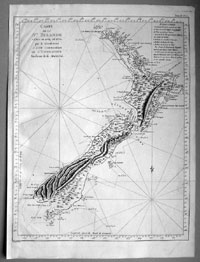
This fine, large, very
handsome & incredibly important original antique map of
New Zealand - the 1st complete map of the Islands - by
Lieutenant James Cook during his first voyage of
discovery to the Southern Hemisphere (between 1768 & 1771) - was published in the 1st French
version of John Hawkesworth's voyages in 1774.
The map was engraved
by the eminent French engraver Robert Benard,
responsible for many of the prints and maps of the
French period of enlightenment during the 18th century.
Before James Cook only the
Dutchman Abel Tasman had charted any of the New Zealand
coastline in 1642 some 127 years previously. So accurate
were Cook's survey's of the New Zealand coastline in
1769 that some of his survey data was still in use 100
years after his first work.
This map is in excellent condition, light folds as
issued on clean very heavy sturdy and stable paper. The
impression is heavy clear indicating it is from a very
early pressing.
Cook's First Voyage
(1768-1771)
The first voyage under
Captain James Cook's command was primarily of a
scientific nature. The expedition on the Endeavour
initially sailed to Tahiti to observe the transit of the
planet Venus in order to calculate the earth's distance
from the sun. Cook landed on the South Pacific island in
April of 1769 and in June of that year the astronomical
observations were successfully completed. In addition to
these labors, very good relations with the Tahitians
were maintained and the naturalists Joseph Banks and
Daniel C. Solander conducted extensive ethnological and
botanical research.
Another purpose of the voyage was to explore the South
Seas to determine if an inhabitable continent existed in
the mid-latitudes of the Southern Hemisphere. Upon
leaving Tahiti, Cook named and charted the Society
Islands and then continued southwest to New Zealand. His
circumnavigation and exploration of that country also
resulted in a detailed survey. Cook proceeded to
Australia, where he charted the eastern coast for 2,000
miles, naming the area New South Wales. As a result of
these surveys, both Australia and New Zealand were
annexed by Great Britain. In addition to these
explorations, the Endeavour returned to England
without a single death from scurvy among its men, an
historic feat at the time. The combination of these
accomplishments brought Cook prominence, promotion, and
the opportunity to lead further expeditions.
(Ref Tooley; M&B; Clancy)
General Description:
Paper
thickness and quality: - Heavy and stable
Paper color: - White
Age of map color: -
Colors used: -
General color appearance: -
Paper size: - 21in x 17 1/2in (535mm x 445mm)
Plate size: - 20in x 16in (510mm x 405mm)
Margins: - 1/2in (12mm)
Imperfections:
Margins: - Bottom half left margin extended from just outside
border
Plate area: - Folds as issued, light creasing
Verso: - None
If you wish to discuss this or any other item
please email or call - good luck, Simon.
Classical Images
61 (0) 409 551910 Tel
simon@classicalimages.com

Web Counter
|