Search the entire catalogue by entering a key search term in the ‘search’ box or browse our stock by selecting from the list of categories below.
MAPS AMERICA
![]()
CARIBBEAN
![]()
|
|||||||||||||
|
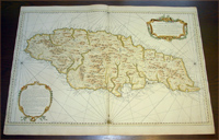
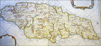
Cartographer : | Jacques Nicolas Bellin | |||||||||||
| Title : | Carte Particuliere De L'Isle De La Jamaique ...MDCCLVIII | ||||||||||||
| Date : | 1758 | ||||||||||||
| Size : | 36in x 25in (910mm x 635mm) | ||||||||||||
| Description : |
This very large finely
engraved beautifully hand coloured original antique map,
sea chart,
of the Caribbean Island of Jamaica was
engraved and published by Jacques Nicolas Bellin in 1758 - dated
in the title cartouche.
General Description:
Imperfections:
If you wish to discuss this or any other item |
||||||||||||
| Condition : | (A+) Fine Condition | ||||||||||||
| Price :
Ref. No. : |
|||||||||||||
|
|||||||||||||