Search the entire catalogue by entering a key search term in the ‘search’ box or browse our stock by selecting from the list of categories below.
MAPS AMERICA
![]()
SOUTH AMERICA
![]()
|
|||||||||||||
|
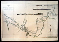
Cartographer : | James Cook | |||||||||||
| Title : | Carte Du Detroit De Magellan dans laquelle on a Insere Les Observations et Les Decouvertes Du Capne | ||||||||||||
| Date : | 1785 | ||||||||||||
| Size : | 30 1/2in x 21 1/2in (775mm x 545mm) | ||||||||||||
| Description : |
This fine large hand coloured original antique
map of the Straits of Magellan and the Patagonian shore South America was
published in 1785 in the French edition of Cooks Voyages. This detailed map includes information on
shoreline topography, different channels, soundings, shoals, harbors and small
islands. Anchorages, capes & bays. Top of chart includes 4 finely engraved
landfall approach views of 1.Vue Du Port Famine 2. Cap Beau Tems 3.Cap Des
Vierges 4. Rochers blanc. (white rocks). Chart includes large compass rose and
depicts the discoveries of the navigators, Byron, Wallis and Carteret. Cook was recognized by his contemporaries
as a highly competent navigator and scientific observer. The map clearly details
his departure from the more established routes crossing the Pacific at a higher
latitude, making it inevitable that he reached New Holland's east coast. Note
the more northerly route taken by Cooks predecessors through calmer waters, thus
missing the prize of the east coast of Australia. Paper thickness and
quality: - Very heavy and stable Imperfections: |
||||||||||||
| Condition : | (A+) Fine Condition | ||||||||||||
| Price :
Ref. No. : |
|||||||||||||
|
|||||||||||||