Search the entire catalogue by entering a key search term in the ‘search’ box or browse our stock by selecting from the list of categories below.
MAPS AUSTRALIA/PACIFIC
![]()
AUSTRALIA
![]()
|
|||||||||||||
|
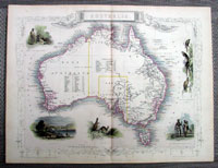
Cartographer : | John Tallis | |||||||||||
| Title : | Australia; New South Wales; Victoria or Port Phillip; Van Diemens Land or Tasmania; South Australia | ||||||||||||
| Date : | 1851 | ||||||||||||
| Size : | 14in x 10 ½in (355mm x 265mm)Each | ||||||||||||
| Description : |
These six is finely engraved
beautifully hand coloured original antique maps of
Australia and the 5 Australian States at the time of
publishing - NSW, Victoria, Tasmania, South Australia
and Western Australia - all with several vignettes of
city views, Aboriginals and various wildlife - was engraved
by John Rapkin and published by John Tallis in 1851. General Description: Imperfections: To discuss please
contact me:
|
||||||||||||
| Condition : | (A+) Fine Condition | ||||||||||||
| Price :
Ref. No. : |
|||||||||||||
|
|||||||||||||