Search the entire catalogue by entering a key search term in the ‘search’ box or browse our stock by selecting from the list of categories below.
MAPS WESTERN EUROPE
![]()
ITALY
![]()
|
|||||||||||||
|
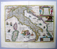
Cartographer : | Henricus Hondius | |||||||||||
| Title : | Italia Nuouamente piu perfetta chemai per inanzi posta | ||||||||||||
| Date : | 1631 | ||||||||||||
| Size : | 22in x 18 1/2in (560mm x 470mm) | ||||||||||||
| Description : |
This finely engraved
beautifully hand coloured original antique map of Italy
was engraved by Henricus Hondius in 1631 - dated bottom
left cartouche - and was published in the 1639 French
edition of Mercator's atlas by Jansson and
Hondius. Background:
Since classical times the countries bordering the
enclosed waters of the Mediterranean had been well
versed in the use of maps and sea charts and in Italy,
more than anywhere else, the traditional knowledge was
kept alive during the many hundreds of years following
the collapse of the Roman Empire. By the thirteenth and
fourteenth centuries the seamen of Venice, Genoa and
Amalfi traded to far countries, from the Black Sea ports
and the coasts of Palestine and Egypt in the East to
Flanders and the southern coasts of England and Ireland
in the West, their voyages guided by portulan charts and
the use of the newly invented compass. For a time
Italian supremacy in cartography passed to Aragon and
the Catalan map makers based on Majorca, but by the year
1400 the power and wealth of the city states of Venice,
Genoa, Florence and Milan surpassed any in Europe.
Florence, especially, under the rule of the Medici
family, became not only a great trading and financial
centre but also the focal point of the rediscovery of
the arts and learning of the ancient world. In this
milieu a number of manuscript world maps were produced,
of which one by Fra Mauro (c. 1459) is the most notable,
but the event of the greatest importance in the history
of cartography occurred in the year 1400 when a
Florentine, Palla Strozzi, brought from Constantinople a
Greek manuscript copy of Claudius Ptolemy's
Geographia, which, 1,250 years after its
compilation, came as a revelation to scholars in Western
Europe. In the following fifty years or so manuscript
copies, translated into Latin and other languages,
became available in limited numbers but the invention of
movable-type printing transformed the scene: the first
copy without maps being printed in 1475 followed by many
with copper-engraved maps, at Bologna in 1477, Rome
1478, 1490, 1507 and 1508, and Florence 1482. General Description:
If you wish to discuss this or any other item |
||||||||||||
| Condition : | (A+) Fine Condition | ||||||||||||
| Price :
Ref. No. : |
|||||||||||||
|
|||||||||||||