Search the entire catalogue by entering a key search term in the ‘search’ box or browse our stock by selecting from the list of categories below.
MAPS WESTERN EUROPE
![]()
ITALY
![]()
|
|||||||||||||
|
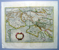
Cartographer : | Gerard Mercator | |||||||||||
| Title : | Karstia, Carniola, Histria et Windorum Marchia | ||||||||||||
| Date : | 1639 | ||||||||||||
| Size : | 21 1/2in x 18 1/2in (550mm x 470mm) | ||||||||||||
| Description : |
This
beautifully hand coloured original antique map of
northern Adriatic Sea and the Gulf of Venice centered on
Istria, showing present-day north-eastern Italy, a large
part of Slovenia and northern Croatia - extending from
Venice to the Island of Arbe and from Doblach to Pettau
on the Dravus River - engraved by Gerard
Mercator, was published by 1639 French edition of Mercators
Atlas by Jan Jansson and Henricus Hondius.
Jodocus
Hondius (1563 - 1612), one of the most notable
engravers of his time, is known for his work in
association with many of the cartographers and
publishers prominent at the end of the sixteenth and the
beginning of the seventeenth century.
Condition Report:
Imperfections:
If you wish to discuss this or any other item |
||||||||||||
| Condition : | (A) Very Good Condition | ||||||||||||
| Price :
Ref. No. : |
|||||||||||||
|
|||||||||||||