Search the entire catalogue by entering a key search term in the ‘search’ box or browse our stock by selecting from the list of categories below.
MAPS AMERICA
![]()
NORTH AMERICA
![]()
|
||||||||||
|
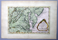
Cartographer : | Jacques Nicolas Bellin | ||||||||
| Title : | Carte De La Virginie, De La Baye Chesapeack, et Pays Voisins... | |||||||||
| Date : | 1755 | |||||||||
| Size : | 14 1/2in x 10in (370mm x 255mm) | |||||||||
| Description : |
This beautifully engraved hand coloured original antique map of Virginia, Chesapeake Bay, New Jersey, Pennsylvania & Maryland was published in 1755 by Jacques Nicolas Bellin for Antoine-François Prevosts 20 volume edition of L`Histoire Generale des Voyages published by Pierre de Hondt, The Hague between 1747 & 1785. (Ref: Tooley; M&B)
General Description:
Imperfections:
If you wish to discuss this or any other item |
|||||||||
| Condition : | (A+) Fine Condition | |||||||||
| Price :
Ref. No. : |
||||||||||
|
||||||||||