Search the entire catalogue by entering a key search term in the ‘search’ box or browse our stock by selecting from the list of categories below.
MAPS AFRICA
![]()
ALGERIA
![]()
|
|||||||||||||
|
Cartographer : | J B Homann | |||||||||||
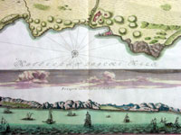
| Title : | Topographica Repræsentatio Barbarici Portus et Urbis Munitæ Oran... Nuremberg, 1732 | ||||||||||||
| Date : | 1735 | ||||||||||||
| Size : | 24 1/2in x 21 1/4in (620mm x 540mm) | ||||||||||||
| Description : |
This large fine beautifully hand coloured original antique map and view of the City of Oran & Environs in the North African country of Algeria, as it was being captured by the Spanish in 1732, was published by Homann Heirs in ca 1735. Chart of the environs of Oran in Algeria, with a panorama of the city and environs, decorated with several sailing battle ships. In 1509 Spain captured Oran from the Moors, but in 1708, with Spain disadvantaged by the War of the Spanish Succession, they were driven out by the Turkish Bey, Mustapha Ben Youssef. In 1732 José Carrillo de Albornoz, 1st Duke of Montemar (1671-1747), recaptured Oran, causing this map to be published, after which the Spanish held the city until 1792. When the Spanish saw no point in keeping it, when it was handed over to the Bey of Algiers (Ref: Tooley; M&B)
General
Description:
Imperfections:
If you wish to discuss this or any other item |
||||||||||||
| Condition : | (A+) Fine Condition | ||||||||||||
| Price :
Ref. No. : |
|||||||||||||
|
|||||||||||||