GO! View Basket

Search the entire catalogue by entering a key search term in the ‘search’ box or browse our stock by selecting from the list of categories below.

MAPS AMERICA

SOUTH AMERICA

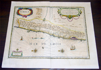
Antique Map of Chile, South America by Hondius (43146)
VIEW ITEM / MORE INFO
Cartographer : Henricus Hondius
Title : Chili
Date : 1639
Size : 22in x 19in (550mm x 470mm)
Description :

This fine beautifully hand coloured original  antique and very important map of the South American country of Chile was published in the 1639 French edition of Mercators Atlas by Jan Jansson and Henricus Hondius.
Background:
The map highlights the coastal region of central Chile from Copiapo in the north (near the left-hand margin) as far as a point to the south of the island of Chiloé.
Apart from the relatively large island of Chiloé, it is readily apparent that little was known of the fjord-like nature of the coast or the  offshore islands of the Archipelago de los Chonos.
The modern cities of Santiago (marked as 'S Iago dela Nueva Estremadura'), Valparaíso (marked as a river estuary on Blaeu's map), Conceptión and Valdivia (spelled 'Baldivia' on the map) stand out clearly, the latter three having all been founded during the mid-sixteenth century by the then governor of central Chile, Pedro de Valdivia."
 (Ref: Koeman; M&B)

Condition Report
Paper thickness and quality: - Heavy and stable
Paper color: - off white
Age of map color: - Original
Colors used: - Red, yellow, green
General color appearance: - Authentic
Paper size: - 22in x 19in (550mm x 470mm)
Plate size: - 19 1/4in x 15in (485mm x 380mm)
Margins: - Min 1in (25mm)

Imperfections:
Margins: - Bottom corners extended
Plate area: - Light age toning
Verso: - Light age toning

If you wish to discuss this or any other item
please email or call...Simon

61 (0) 409 551910 Tel
simon@classicalimages.com

Condition : (A+) Fine Condition

Price :

Ref. No. :

US$475.00

43146

add to basket

payment
shipping
ask a question