|
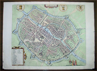
This fine beautifully
hand coloured
original antique map a birds-eye
view of
the town of
Tournai or Doornik, a Walloon city located 85 kilometres
west-southwest of Brussels, on the river Scheldt, in the
province of Hainaut
in Belgium was published by Georg Braun
& Frans Hogenberg for the 1575 atlas of town plans
Civiates Orbis Terrarum Vol II (1572-1612) intended as a
companion to Abraham Ortelius's master Atlas Theatrum
Orbis Terrarum published in 1570.
Background: Bird's-eye view of the city from the
south seen fortified with a Renaissance-style moat and
wall with projecting bastions. The Old Town wall, dating
from 1290, can be seen inside the city. The 12th-century
Gothic cathedral of Notre-Dame (5) stands out in the
centre , the most important and influential church
building in Belgium.
Tournai is one of Belgium's oldest cities. A formidable
stronghold as early as the 4th century AD, it was the
main centre of the Salian Franks until the mid-5th
century. Tournai became an Episcopal See at the
beginning of the 6th century and belonged then to the
Count of Flanders from 1188 to France.
In the 15th century the city flourished economically and
culturally as a result of its tapestry industry (Rogier
van der Weyden, among others). In the Treaties of Madrid
and Cambrai (1526/29), France had to cede Tournai to
Charles V and it thus became part of the Spanish
Netherlands.
COMMENTARY BY BRAUN on the Verso: "Tornacum or
Turnacum is a city in Gallia Belgica, situated on the
Schelde in the territory of the Nervii, called Tournai
by its French inhabitants, but Dorneck by the Germans.
Tournai has always been a large and powerful city, with
an abundance of goods and commercial activities and
wonderfully resourceful craftsmen, who invent new
articles every day, and although some of these go out of
use they constantly conceive of other new things, both
useful and delightful, so that they have at all times
something that provides work and a means of livelihood
for the poor."
Background of Civitates
Orbis Terrarum:
The first volume of the Civitates
Orbis Terrarum was published in Cologne in 1572. The sixth and the final volume
appeared in 1617.
This great city atlas, edited by Georg Braun and largely engraved by Franz
Hogenberg, eventually contained 546 prospects, bird-eye views and map views of
cities from all over the world. Braun (1541-1622), a cleric of Cologne, was the
principal editor of the work, and was greatly assisted in his project by the
close, and continued interest of Abraham Ortelius, whose Theatrum Orbis Terrarum
of 1570 was, as a systematic and comprehensive collection of maps of uniform
style, the first true atlas.
For a variety of reasons town plans were comparatively
latecomers in the long history of cartography. Few
cities in Europe in the middle ages had more than 20,00
inhabitants and even London in the late Elizabethan
period had only 100-150,000 people which in itself was
probably 10 times that of any other English city. The
Nuremberg Chronicle in 1493 included one of the first
town views of Jerusalem, thereafter, for most of the
sixteenth century, German cartographers led the way in
producing town plans in a modern sense. In 1544
Sebastian Munster issued in Basle his Cosmographia
containing roughly sixty-six plans and views, some in
the plan form, but many in the old panorama or birds eye
view. (Ref: Tooley; M&B)
Condition Report:
Paper thickness and quality: - Heavy and stable
Paper color: - off white
Age of map color: - Early
Colors used: - Green, blue, red, yellow
General color appearance: - Authentic
Paper size: - 21 1/2in x 16in (550mm x 400mm)
Plate size: - 16 3/4in x 14 1/4in (440mm x 365mm)
Margins: - Min 1in (25mm)
Imperfections:
Margins: - Light chipping to margin edges
Plate area: - None
Verso: - None
If you wish to discuss this or any other item
please email or call...Simon
61 (0) 409 551910 Tel
simon@classicalimages.com
|