Search the entire catalogue by entering a key search term in the ‘search’ box or browse our stock by selecting from the list of categories below.
MAPS WESTERN EUROPE
![]()
AUSTRIA
![]()
|
|||||||||||||
|
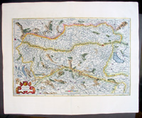
Cartographer : | Gerard Mercator | |||||||||||
| Title : | Austria archiducatus | ||||||||||||
| Date : | 1609 | ||||||||||||
| Size : | 22in x 18in (560mm x 460mm) | ||||||||||||
| Description : |
This beautifully engraved hand coloured
original antique map of Austria was published in the 1609 French edition of
Mercator's Atlas released by Henricus Hondius and Jan Jansson. After the sale of Mercator's plates to in 1605, Hondius continued to publish the original plates with little alteration until 1630 when along with Jansson many of the original plates were altered or re-engraved either decoratively or topographically or both. This map is from one of the last unaltered editions of Mercator's atlas. (Ref: Koeman, Tooley)
Condition Report
Imperfections: |
||||||||||||
| Condition : | (A+) Fine Condition | ||||||||||||
| Price :
Ref. No. : |
|||||||||||||
|
|||||||||||||