Search the entire catalogue by entering a key search term in the ‘search’ box or browse our stock by selecting from the list of categories below.
MAPS AMERICA
![]()
SOUTH AMERICA
![]()
|
|||||||||||||
|
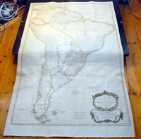
Cartographer : | Thomas Bowen | |||||||||||
| Title : | South America Performed Under The Patronage of Louis Duke of Oreleans....T. Bowen 1755 | ||||||||||||
| Date : | 1755 | ||||||||||||
| Size : | 51 1/2in x 31 1/2in (1.31mm x 800mm) | ||||||||||||
| Description : |
This very large 3
sheet joined copper-plate engraved original antique map
of South America was engraved by Thomas Bowen in 1755 -
the date is engraved at the foot of the map - and was
published by Solomon Bolton for Malachy Postlethweyt's 2
Volumes publication of Dictionary of Trade & Commerce
published in 1757. This map from the
second edition of this famous dictionary, based in part
on the Dictionaries universel de Commerce (Paris:
1723-30) of Jacques Savary de Bruslon, under whose name
it is often catalogued, but was adapted by Postlethwayt
for a British audience, with substantial enlargements
and improvements, and entirely new material relating to
England and her colonies. Postlethwayt devoted twenty
years to the preparation of the dictionary, which was
first published in 1751-55. The dictionary included a
description of British affairs in North America since
the peace of 1763. As with his other works, the
dictionary demonstrates Postlethways deep commitment to
the expansion and strengthening of English trade.
Included are entries for geographical locations (Africa,
Antilles, Canada, Japan, Louisiana, &c.), products
(brandy, cardamom, codfish, diamonds, sugar, &c.),
trading companies (Dutch East India Company, English
African Company, &c.), treaties of commerce, and a vast
range of other information of value to merchants
(bankruptcy, currency, bills of exchange, brokerage,
exportation, landed interest, privateering, &c.).
General Description: |
||||||||||||
| Condition : | (A+) Fine Condition | ||||||||||||
| Price :
Ref. No. : |
|||||||||||||
|
|||||||||||||