|
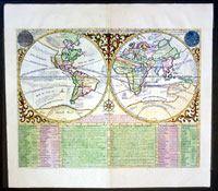
This fine
beautifully
hand coloured original antique Twin Hemisphere World map
by
Henri
Abraham
Chatelain in 1708 was published in
his famous
Atlas Historique.
This is a magnificent map with bright hand colouring,
clean strong sturdy paper and a heavy clear impression.
A very beautiful double hemisphere world map
surrounded by a florid vine pattern with depictions of
the sun & moon according to Kircher and Cassini.
As was the majority of opinion of the day California is
depicted as an Island with the NW American coastline
stretching almost to China. As this is a French map,
France is shown as the major colonial power in North
America with the original 13 colonies represented as
Virginia.
Australia or New Holland shows a nearly complete
northern and western coastline thanks in no small part
to the Spice traders who used the southern trade winds,
sometimes inaccurately, to reach the Dutch East Indies.
Cooks discovery of the east coast was still 70 years
away.
The central southern coastline of New Holland is shown
joined to the mythical great Southern land or Terres
Australis Inconnues. This depiction shows the
growing uncertainty of the actual existence of a great
southern land, as more data reached Europe,
contradicting the long held belief in a vast southern
continent "balancing" the globe, to Europe in the north.
The voyages of Drake, Cavandish, and others are shown
along with Nuyts discoveries on the South Australian
coast on his voyage in 1627. New Holland is noted as
having been discovered in 1644 while on the other hand a
number of the earlier Dutch discoveries are also noted.
Tracks of a number of other explorers are shown as is an
outdated route to the Indies, by traversing the Indian
Ocean directly to Java in a north easterly direction. By
1617 the VOC required all their ships traveling to the
East Indies to take the route pioneered by Hendrik
Brouwer in 1610 which was to utilise the strong winds
known as the Roaring Forties sailing in a south easterly
direction and then turning due north to Java on nearing
the Australia coast.
Below the map are tables of French text listing the
nations of the world and geographic terms.
The Atlas Historique
published by
Henri Chatelain
was part of a major work of its time, an encyclopedia in
seven volumes, including geography as one of its main
subjects. The text was by Nicholas Gueudeville and the
maps by Chatelain. The Atlas included one of the finest
map of America (four sheets) surrounded by vignettes and
decorative insets.
The
Atlas Historique was completed between 1705 and
1720, further issues were published up to 1739. The
series was published in Amsterdam, with Chatelains maps
based on those of G. Delisle.
(Ref: M&B; Tooley)
General Description:
Paper thickness and quality: - Heavy and stable
Paper color: - White
Age of map color: - Later
Colors used: - Pink, green, yellow
General color appearance: - Authentic
Paper size: - 19in x 17in (485mm x 430m)
Plate size: - 17 1/2in x 13 1/2in (445mm x 345mm)
Margins: - min. 1in (25mm)
Imperfections:
Margins: - None
Plate area: - None
Verso: - None
|