|
We are
sometimes fortunate to come across an original antique
map that is not only rare but of profound importance.
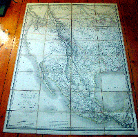
Such is the case with this large & rarely found folding
map of Texas, Mexico, California & the West by Pierre
Antoine Tardieu, engraved in
1820 - dated - by Tardieu & Charles
Picquet (1771-1827) and published by J Goujon in Paris.
Original Sold by W Faden Geographer to His Majesty
sticker on the back of the map. Please contact me
directly at
simon@classicalimages.com
or call 61-3-94972845 if you have any questions.
What makes this map so
important is that it was printed within the same 10 year
period of 5 other famous landmark maps by Von
Humboldt, Pike, Lewis & Clark, Arrowsmith and Melish.
All published maps covering all or some of the same
geographical regions of Mexico, Texas, California and
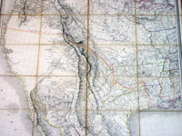
the West. At the bottom of this map Tardieu writes in
English....
"This Map is executed according to the astronomical
observations of Baron de Humboldt, and Don Joaquin de
Ferrer. For Upper Louisiana, we have profited of the
maps and travels of Pike, and those of Lewis and Clark;
for Lower Louisiana, of the map and description of this
State by M. Darby; for the Territory of Arkansas and the
Province of Texas, of the map of the United States by M.
Melish; and for Mexico, of the map of New Spain by Baron
de Humboldt, and that of this country by M.
Arrowsmith...."
To be more precise the maps are;
1.
Alexander von Humboldt 1811 - "A New Map of Spain"
2. Z M Pike 1810 - "A Map of The Internal Provinces
of New Spain"
3. Lewis and
Clark 1814 - "Map of Lewis and Clark's Track, Across
the Western Portion of North America"
4. Aaron Arrowsmith 1816 - "A New Map of Mexico"
5. John Melish 1816 - "Map of The United States"
By themselves each of these maps had a profound affect
on the understanding of the region and the eventual
expansion of the United States. Tardieus
compared, analysed & combined the correct data from each
map, as well as new information from other sources, and
publish a large scale map stretching from the edge of the
established western United States to Texas, Mexico, California & the
southwest.
Another unique quality of the map is the
use of English in a French published map. Not only is the
title in English first, but most of the place names and
observations are also written in English. Very unusual
for a French map of the period, which illustrates how shrewd Tardieu was,
marketing the map to the newly independent American home
market.
Because there is 10 years difference between publication
of these maps, each had their own mistakes and
idiosyncrasies. For instance, although De Humboldt spent
many months in Mexico researching for his book and maps
of New Spain, he eventually used the wrong observations
of Gen. James Wilkinson on the depiction of the Texas
rivers, giving them too much southerly direction. Pike
on the other hand explored parts of Texas himself and depicted the rivers in their correct SE
direction, but Pike's delineation of
the Texas coast followed the incorrect Jeffery's model
instead of the far superior & up to date model
used by Humboldt from Mexican data.
Arrowsmith's approach to cartography differed again from both Humboldt's and Pikes. He used data
from various different sources, rather than
predominately from a single source and scientific hypothesis
as did Humboldt, or the more direct military reconnaissance approach of
Pike.
There is no doubt that Arrowsmith borrowed heavily from
both Humboldt's & Pikes maps of Texas, but what makes
his map a stand out is the use of data and observations
from sources such as the Hudson Bay Company to expanded
his map to include more of Louisiana, California and the
NW.
The Lewis and Clark
Expedition of 1804-06 gained an understanding of the
geography of the west & northwest and produced the first
accurate maps of the region. During the journey, Lewis and
Clark drew some 140 maps. The discoveries made on
the expedition helped Tardieu update many details of
his map. One detail of significance was the relationships and sources of the
Columbia & Missouri Rivers as well as the previously
underestimated domination of the Rocky Mountains.
The large Melish map of 1816 stretching from the East Coast to California was of vital importance to Tardieus map.
It
gave him the boundaries agreed to by the Adams-Onis
treaty between Spain & The United States in which the US
gave up its claims to Texas in exchange for Spain's
claim on Florida. Melish's Philadelphia publishing
company was also one of the first in the newly independent US to be
devoted to the publication of cartographical material. He had recognised
the potential of expansion into the west and so
accumulated vast amounts of detail in which to include
in his extremely popular 1816 large 6 sheet map. He also
included data from William Darby who had personally
surveyed the Sabine River & other parts of Texas. Melish
published Darby's map of The State of Louisiana
in 1816.
The progression of maps from Humboldt's to Pike &
Arrowsmith's is obvious and with the publication of the
Lewis & Clark map of the West in 1814 & the large scale
America map by John Melish in 1816, Tardieu was in a
unique position to produce an accurate and definite map that combined details from all maps.
In the end, Tardieu's map of
Texas, Mexico and the West may be seen as a
natural progression from previous cartographical
iteration.
But the sign of a incisive mind is the ability to
research and define the mistakes of others and have the conviction
to correct popular belief and to publish, in this case
to a growing and emerging market.
There are only 2 published sales of this map in AMPR in
the last 25 years. There are sales of the southern sheet
of two (in its other form) but none of the northern
sheet. In comparison there are 7 sales records of Von
Humboldts map with a top price of $22,500. One sales
record for Lewis & Clark of $18,000 in 2006. Four sales
of Arrowsmith's map with a top of $39,100 & 10 sales of
the Melish map with a top price of $75,000 in 2008.
(Ref:
Wheat; Martin; Streeter; M&B; Tooley)
General Description:
Paper thickness and quality: - Heavy & stable
Paper color: - White
Age of map color: - Original
Colors used: - Pink, green, yellow
General color appearance: - Authentic
Paper size: - 44 1/2in x 33in (1.14m x
845mm)
Paper size: - 44 1/2in x 33in (1.14m x
845mm)
Margins: - Min 1in (25mm)
Imperfections:
Margins: - Light soiling to margins
Plate area: - Light soiling to canvas folds, bottom left
section restored from original southern sheet
Verso: - Light soiling to canvas folds
|