Search the entire catalogue by entering a key search term in the ‘search’ box or browse our stock by selecting from the list of categories below.
MAPS AMERICA
![]()
SOUTH AMERICA
![]()
|
|||||||||||||
|
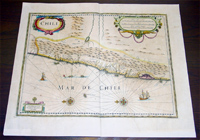
Cartographer : | Henricus Hondius | |||||||||||
| Title : | Chili | ||||||||||||
| Date : | 1639 | ||||||||||||
| Size : | 22in x 19in (550mm x 470mm) | ||||||||||||
| Description : |
This fine
beautifully hand coloured original antique and
very important map of the South American country of
Chile was published in
the 1639 French edition of Mercators
Atlas by Jan Jansson and Henricus Hondius.
Condition Report
Imperfections:
If you wish to discuss this or any other item |
||||||||||||
| Condition : | (A+) Fine Condition | ||||||||||||
| Price :
Ref. No. : |
|||||||||||||
|
|||||||||||||