Search the entire catalogue by entering a key search term in the ‘search’ box or browse our stock by selecting from the list of categories below.
MAPS AMERICA
![]()
![]()
|
|||||||||||||
|
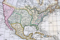
Cartographer : | Claude Delisle | |||||||||||
| Title : | Carte D ' Amerique Dresse Pour L Instruction Par Guil Delisle | ||||||||||||
| Date : | 1790 | ||||||||||||
| Size : | 25 1/2in x 19 1/2in (650mm x 495mm) | ||||||||||||
| Description : |
This large
beautifully engraved hand coloured original antique map
of America was published in 1722 by
Claude de L'Isle (Delisle) and re-issued in nineteen
different states by Delisle and Phillip Bauche between
1722 & 1830 - the date 1790 is engraved in the title
cartouche. The map
illustrates an immense amount of detail. The map
includes an inset map of the discoveries of Capt Cook in
the American NW, California is noticeably different and
the names along the west coast are altered from the
original engraving e.g. Monterey is now shown at the
head of the R. du Carmel. To the north appears entree
d' Aguilar, entree du Roi Georges and Fousang des
Chinois. The great lakes are now more accurately
drawn and the huge L. Bourbon compressed. Port Royale,
Halifax, Plaisance (Newfoundland) Portsmouth,
Philadelphia &c. are shown. The Papal line of
Demarcation and the Isles de Quiros are erased and the
title cartouche enlarged. Easter Island now lettered "L
de Pasques vue par Davis".
Condition Report |
||||||||||||
| Condition : | (A+) Fine Condition | ||||||||||||
| Price :
Ref. No. : |
|||||||||||||
|
|||||||||||||