|
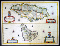
This fine
beautifully hand coloured original antique map of the
Caribbean Islands of Jamaica & Barbados by Francis Lamb
was published by Thomas Basset & Richard Chiswell in the
1676 edition of John Speeds A Prospect of The Most
Famous Parts of The World.
This is one of the new maps engraved by Francis Lamb for
the final edition of John Speed's great world atlas. At
top is a fine map showing the precincts
(parishes) in Jamaica, and at bottom is a detailed map
of Barbados. Each is beautifully engraved to illustrated
topography and richly adorned with cartouches, sailing
ships, sea monsters, the royal arms and compass roses.
Basset and Chiswell's imprint in the Jamaica cartouche.
English text on verso with fascinating descriptions of
the islands.
We have AMPR records of 22 sales in the last 25 years
for this map with a top price of $2274 paid in 2005.
John Speed (1552-1629)
Born at Farndon in
Cheshire and followed his father's trade as a tailor. By
1584 he had moved to London with his wife (Susanna who
bore twelve sons and six daughters) and been made a
Freeman of Merchant Tailors in 1580.
He was a keen amateur historian and map maker, producing
maps for the Merchant Tailors in 1598. Became a member
of the Society of Antiquaries where it is likely that he
came into contact with leading historians of the day
such as Sir Robert Cotton, William Camden, whose text he
had read, and perhaps even Christopher Saxton. His
interests came to the notice Sir Fulke Greville who made
an allowance so that he should be free to write a
history of England and, by courtesy of Queen Elizabeth,
he worked from a room in the Custom House.
A good historian, he was a great gatherer of information
'I have put my sickle to other men's corne'.
Most of his map material was copied from Saxton:
however, John Norden (c.1548-1625)) and William Smith
(c.1550-1618) had produced maps of some countries and
Gerard Mercator maps of the regions. Yet Speed must have
travelled extensively, for his maps go well beyond those
of his predecessors. By including the hundreds, the
inset town plans and heraldic devices of his maps and
modifying the Camden text in the atlas he assured its
success and lasting appeal. (Ref: Tooley; M&B)
General Description:
Paper thickness and quality: - Heavy and stable
Paper color: - off white
Age of map color: - Original
Colors used: - Yellow, green, blue, red, pink
General color appearance: - Beautiful
Paper size: - 20 1/2in x 16in (520mm x 405mm)
Plate size: - 20in x 15 1/4in (509mm x 390mm)
Margins: - Min 1/2in (12mm)
Imperfections:
Margins: - Light spotting in top margin
Plate area: - None
Verso: - None
|