Search the entire catalogue by entering a key search term in the ‘search’ box or browse our stock by selecting from the list of categories below.
MAPS AMERICA
![]()
SOUTH AMERICA
![]()
|
||||||||||
|
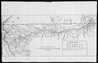
Cartographer : | Samuel Fritz | ||||||||
| Title : | The Great Maranon or of the Amazons Geographically described by Samuel Fritz Missioner | |||||||||
| Date : | 1714 | |||||||||
| Size : | 14 1/4in x 9in (365mm x 230mm) | |||||||||
| Description : |
This fine scarce
original antique map of Samuel Fritz's highly important
map of the Marañon and Amazon Rivers, was first printed
in Quito in 1707 and was published in In
Lettres édifiantes et curieuses. Écrites des missions
etrangères, par quelques missionaries de la compagnie de
Jesus, Paris, N. Le Clerc, 1717, and thereafter in
subsequent editions of the reports of the Jesuit
Missionaries.
General Description:
Imperfections: |
|||||||||
| Condition : | (A) Very Good Condition | |||||||||
| Price :
Ref. No. : |
||||||||||
|
||||||||||