Search the entire catalogue by entering a key search term in the ‘search’ box or browse our stock by selecting from the list of categories below.
MAPS AMERICA
![]()
NORTH AMERICA
![]()
|
|||||||||||||
|
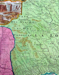
Cartographer : | J B Homann | |||||||||||
| Title : | Amplissimae Regionis Mississipi seu Provinciae Ludovicianae a R.P. Ludovico Hennepin Francisc.... | ||||||||||||
| Date : | 1720 | ||||||||||||
| Size : | 24in x 20 1/2in (610mm x 530mm) | ||||||||||||
| Description : |
This large finely engraved beautifully hand coloured original antique map of the United States, the Mississippi River, North America, was published by J.B Homann in 1720
This
iconic
map of the Mississippi River Valley by Johann Baptiste
Homan is commonly called the 'Buffalo Map' for its
distinctive decorative elements depicting a stylized
buffalo. This map is derived from an earlier 1718 map of
the same region by G. De L'Isle though it has been
enlarged to include New England.
General
Description:
Imperfections:
If you wish to discuss this or any other item |
||||||||||||
| Condition : | (A+) Fine Condition | ||||||||||||
| Price :
Ref. No. : |
|||||||||||||
|
|||||||||||||